|
EL NIÑO/SOUTHERN OSCILLATION (ENSO) |
DIAGNOSTIC DISCUSSION |
issued by CLIMATE PREDICTION CENTER/NCEP/NWS |
|
11 May 2023 |
ENSO Alert System Status: El Niño Watch |
Synopsis: A transition from ENSO-neutral is expected in the next couple of months, with a greater than 90% chance of El Niño persisting into the Northern Hemisphere winter. During April, above-average sea surface temperatures (SSTs) expanded slightly westward to the east-central equatorial Pacific Ocean [Fig. 1]. The latest weekly Niño-3.4 index value was +0.4°C, with the easternmost Niño-3 and Niño1+2 regions at +0.8°C and +2.7°C, respectively [Fig. 2]. Area-averaged subsurface temperatures anomalies continued to increase [Fig. 3], reflecting widespread positive temperature anomalies below the surface of the equatorial Pacific Ocean [Fig. 4]. Low-level wind anomalies were westerly during mid-April before switching back to easterly by the end of the month. Upper-level wind anomalies were westerly across most of the Pacific Ocean. Suppressed convection was observed over parts of Indonesia and anomalies weakened near the Date Line [Fig. 5]. While the warming near coastal South America remains striking, the basin-wide coupled ocean-atmosphere system remained consistent with ENSO-neutral.The most recent IRI plume also indicates El Niño is likely to form during the May-July season and persist into the winter [Fig. 6]. The combination of a forecasted third westerly wind event in mid-late May, and high levels of above-average oceanic heat content, means that a potentially significant El Niño is on the horizon. While at least a weak El Niño is likely, the range of possibilities at the end of the year (November-January) include a 80% chance of at least a moderate El Niño (Niño-3.4 ≥ 1.0°C) to a ~55% chance of a strong El Niño (Niño-3.4 ≥ 1.5°C). It is still possible the tropical atmosphere does not couple with the ocean, and El Niño fails to materialize (5-10% chance). In summary, a transition from ENSO-neutral is expected in the next couple of months, with a greater than 90% chance of El Niño persisting into the Northern Hemisphere winter [Fig. 7]. |
You are using an out of date browser. It may not display this or other websites correctly.
You should upgrade or use an alternative browser.
You should upgrade or use an alternative browser.
Have you looked at the North Pole lately?
- Thread starter igrowone
- Start date
Three Berries
Active member
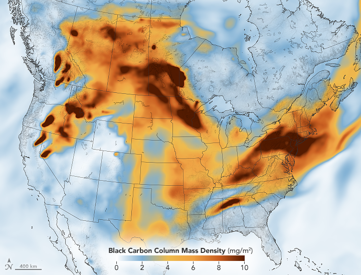
Smoke Across North America
Skies turned hazy from Pittsburgh to Washington to Boston, as smoke from fires in Canada poured into the U.S. Northeast.
NASA Satellite Spots Large Wave Rolling Across Pacific As El Niño Likely Coming
Friday, May 19, 2023 - 02:45 AM
NASA's Jet Propulsion Laboratory in Southern California identified a "potential precursor" of El Niño conditions after one of its satellites spotted a massive wave of warm water moving across the equatorial Pacific.
Described as "Kelvin waves," JPL said the US-European satellite Sentinel-6 Michael Freilich shows raised ocean surface, approximately 2 to 4 inches, and hundreds of miles wide, moving from west to east along the equator.
"A series of Kelvin waves starting in spring is a well-known precursor to an El Niño, a periodic climate phenomenon that can affect weather patterns around the world," JPL said, adding these waves tend to be higher than cooler ocean water because warm water expands.
"We'll be watching this El Niño like a hawk. If it's a big one, the globe will see record warming," Josh Willis, a project scientist on Sentinel-6 Michael Freilich at JPL.
El Niño is also associated with weakening trade winds and can bring cooler, wetter conditions to the US Southwest and drought to countries in the Western Pacific, such as Australia and Indonesia. More specifically, here are the impacts on North America:

As of May 11, NOAA's Climate Prediction Center said the probability of El Niño forming is greater than 90% over the next few months.
We have previously explained to readers that El Niño could affect global weather patterns and cause disruptions in the agriculture sector. Reports of heatwaves in Asia and Europe have already surfaced, with the possibility of rice crops being damaged in Thailand.
And to get the facts straight, the UN Office for the Coordination of Humanitarian Affairs has stated, "El Niño and La Niña are naturally occurring climate patterns, and humans have no direct ability to influence their onset, intensity or duration."
NASA Satellite Spots Large Wave Rolling Across Pacific As El Niño Likely Coming | ZeroHedge
ZeroHedge - On a long enough timeline, the survival rate for everyone drops to zero
"no direct ability'
Fascinating way of a snowfox, sporty 3000 kilometers.
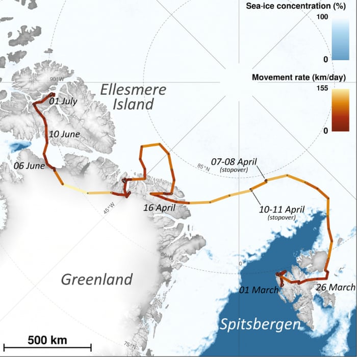
i watched them talking about that fox on a nature special a while back. incredible!
Yes, it´s a while back, the picture of the route (above) I found before years here on IC mag.i watched them talking about that fox on a nature special a while back. incredible!
"have ice, will travel" 
Reduce CO2 & we die!
Geologist and author of 'Green Murder', Dr. Ian Plimer:
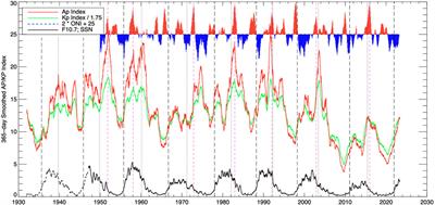
The Triple-Dip La Niña of 2020-22: Updates to the Correlation of ENSO with the Termination of Solar Cycles
The Sun provides the energy required to sustain life on Earth and drive our planet's atmosphere.However, establishing a solid physical connection between solar and tropospheric variability has posed a considerable challenge across the spectrum of Earth-system science. Over the past few years a...
The Triple-Dip La Niña of 2020-22: Updates to the Correlation of ENSO with the Termination of Solar Cycles
 Robert J. Leamon1*
University of Maryland, United States
The Sun provides the energy required to sustain life on Earth and drive our planet's atmosphere. However, establishing a solid physical connection between solar and tropospheric variability has posed a considerable challenge across the spectrum of Earth-system science. Over the past few years a new picture to describe solar variability has developed, based on observing, understanding and tracing the progression, interaction and intrinsic variability of the magnetized activity bands that belong to the Sun's 22-year magnetic activity cycle. A solar cycle's fiducial clock does not run from the canonical min or max, instead resetting when all old cycle polarity magnetic flux is cancelled at the equator, an event dubbed the "termination" of that solar cycle, or terminator. In a recent paper, we demonstrated with high statistical significance, a correlation between the occurrence of termination of the last five solar cycles and the transition from El Niño to La Niña in the Pacific Ocean, and predicted that there would be a transition to La Niña in mid 2020. La Niña did indeed begin in mid-2020, and endured into 2023 as a rare "triple dip" event, but some of the solar predictions made did not occur until late 2021. This work examines what went right, what went wrong, the correlations between El Niño, La Niña and geomagnetic activity indices, and what might be expected for the general trends of large-scale global climate in the next decade.
St. Phatty
Active member
Lecture 2: Wave Nature of the Electron and the Internal Structure of an Atom | Physical Chemistry | Chemistry | MIT OpenCourseWare
MIT OpenCourseWare is a web based publication of virtually all MIT course content. OCW is open and available to the world and is a permanent MIT activity
ocw.mit.edu
Prof. Robert Field talks about structure of the atom, en route to discussing Boyle's Gas Law.
If you want to understand Climate Change, it really helps to understand what chemists call "Physical Chemistry".
What happens when you burn 35 Billion barrels of oil in one year ?
world consumption of oil year by year - Google Search
www.google.com
What happens when you burn 8 billion tons of coal in one year ?
coal consumption by year tons - Google Search
www.google.com
look at the winds...f you want to understand Climate Change, i
St. Phatty
Active member
look at the winds...
Or, specifically, the LACK of wind.
The extreme high temperatures that Texas has right now, are related to a high pressure system that moved in right over the affected areas.
The sun heats the FCUK out of the ground areas during daylight hours, and then the temperatures don't drop at night.
One article I was reading about the current Texas heat wave - temperatures dropped to 90 by near midnight, but then there was an interesting storm with lightning etc. that left temperatures at 100 - at about 12:15 in the morning.
Meanwhile, when the wind blows surprisingly fast, then there is a problem with wildfire. It catches people off guard. The fire-fighters are trained to deal with a wildfire with 20 mile per hour winds.
But when there is a wildfire with 40-50-60 mile per hour winds, they have access to no technology that can deal with that.
i think we all know enough about physical chemistry to know what happens.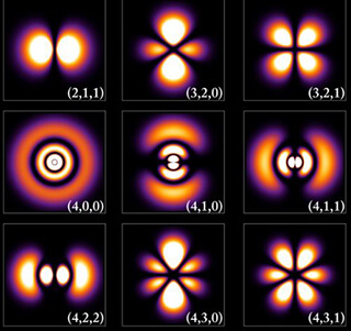
Lecture 2: Wave Nature of the Electron and the Internal Structure of an Atom | Physical Chemistry | Chemistry | MIT OpenCourseWare
MIT OpenCourseWare is a web based publication of virtually all MIT course content. OCW is open and available to the world and is a permanent MIT activityocw.mit.edu
Prof. Robert Field talks about structure of the atom, en route to discussing Boyle's Gas Law.
If you want to understand Climate Change, it really helps to understand what chemists call "Physical Chemistry".
What happens when you burn 35 Billion barrels of oil in one year ?
world consumption of oil year by year - Google Search
www.google.com
What happens when you burn 8 billion tons of coal in one year ?
coal consumption by year tons - Google Search
www.google.com
might you explain how that translates into 'climate change'?
maybe you could link the diminishing magnetic field to co2.

the solar impetus inherent in the record is undeniable.
historically there were more wildfires before industrialization than since, so the correlation is lost as a factor of argument. bad forest management, dry conditions, arsonists, and yes even wind all augment the incidence of wildfire.
and a good summer's evening to you
time to put our hand on mother nature's brow and see how she's feeling
not so good I'm afraid, running a bit of a fever
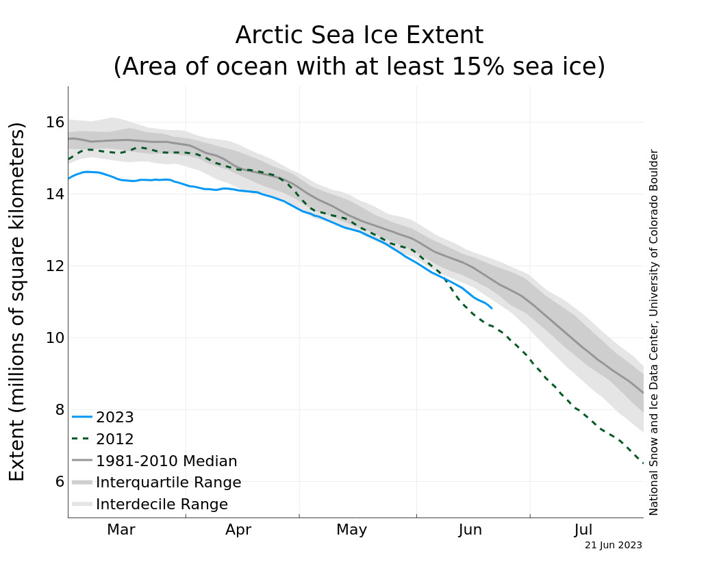
the north pole is so so, not at record lows right now, more of a new normal, could be worse
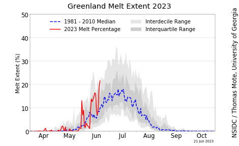
the greenland ice sheet is less happy, melt season starting strong
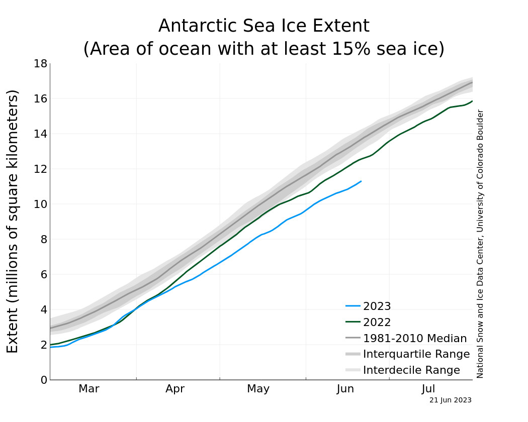
and down at antarctica? oh my, that sea ice is way down to dramatic record lows
time to put our hand on mother nature's brow and see how she's feeling
not so good I'm afraid, running a bit of a fever
the north pole is so so, not at record lows right now, more of a new normal, could be worse
the greenland ice sheet is less happy, melt season starting strong
and down at antarctica? oh my, that sea ice is way down to dramatic record lows
this study indicates that during a magnetic reversal (ongoing currently) charged particle precipitation enters earths atmosphere at the poles, but as the dipole magnetic field collapses these charged particles are distributed globally. possibly the cause of polar heating contemporaneously. your mileage may vary.
full paper here:
https://agupubs.onlinelibrary.wiley.com/doi/10.1029/2023GL103843
Abstract
During the Earth's magnetic reversal, the dipole component of the magnetic field weakens, and the non-dipole component becomes dominant, resulting in a far more complex magnetospheric topology than that of a dipole. In this study, we used a particle tracing technique to investigate the motion of ions within an irregular magnetosphere during the Matuyama-Brunhes magnetic polarity reversal. Compared to the scenario in which the geomagnetic field is dominated by a dipole component, earthward-moving particles can be hardly “trapped” in the inner magnetosphere when the geomagnetic field experiences the polarity reversal, and particles can directly precipitate into the Earth's atmosphere on a global scale. It suggests that under an irregular magnetospheric configuration, the traditional trapped region of particles (e.g., radiation belt or ring current) no longer exists.
Key Points
Plain Language Summary
During the Earth's paleomagnetic reversal, the strength of the Earth's magnetic field was approximately 10% of its current value, accompanied by a weakening of the dipole component and an enhancement of the non-dipole component. Under the superposition of this non-axisymmetric multipole magnetic field, the magnetospheric structures may undergo significant changes. How charged particles travel in such an irregular magnetosphere and how different their trajectories are compared to the well-known textbook scenario are still unknown. In this study, by utilizing global MHD simulations and test-particle tracing techniques, we trace the charged particle's trajectory within the magnetosphere during the Matuyama-Brunhes magnetic polarity reversal. We found that under an irregular magnetosphere in the middle stage of the geomagnetic reversal, particles in the inner magnetosphere cannot be constantly trapped around the Earth. The traditional trapped region (e.g., radiation belt or ring current) no longer exists. Particles moving Earthward do not gain the same acceleration effect as those under the present-day magnetic field topology, resulting in a globally distributed pattern of particle precipitation. These differences can affect the global energy deposition and particle distribution in near-Earth space.
full paper here:
https://agupubs.onlinelibrary.wiley.com/doi/10.1029/2023GL103843
Abstract
During the Earth's magnetic reversal, the dipole component of the magnetic field weakens, and the non-dipole component becomes dominant, resulting in a far more complex magnetospheric topology than that of a dipole. In this study, we used a particle tracing technique to investigate the motion of ions within an irregular magnetosphere during the Matuyama-Brunhes magnetic polarity reversal. Compared to the scenario in which the geomagnetic field is dominated by a dipole component, earthward-moving particles can be hardly “trapped” in the inner magnetosphere when the geomagnetic field experiences the polarity reversal, and particles can directly precipitate into the Earth's atmosphere on a global scale. It suggests that under an irregular magnetospheric configuration, the traditional trapped region of particles (e.g., radiation belt or ring current) no longer exists.
Key Points
- We simulated charged particles' trajectories in the magnetosphere during the Matuyama-Brunhes reversal
- Particles cannot be “trapped” in an irregular magnetosphere
- The irregular geomagnetic field results in global particle precipitation
Plain Language Summary
During the Earth's paleomagnetic reversal, the strength of the Earth's magnetic field was approximately 10% of its current value, accompanied by a weakening of the dipole component and an enhancement of the non-dipole component. Under the superposition of this non-axisymmetric multipole magnetic field, the magnetospheric structures may undergo significant changes. How charged particles travel in such an irregular magnetosphere and how different their trajectories are compared to the well-known textbook scenario are still unknown. In this study, by utilizing global MHD simulations and test-particle tracing techniques, we trace the charged particle's trajectory within the magnetosphere during the Matuyama-Brunhes magnetic polarity reversal. We found that under an irregular magnetosphere in the middle stage of the geomagnetic reversal, particles in the inner magnetosphere cannot be constantly trapped around the Earth. The traditional trapped region (e.g., radiation belt or ring current) no longer exists. Particles moving Earthward do not gain the same acceleration effect as those under the present-day magnetic field topology, resulting in a globally distributed pattern of particle precipitation. These differences can affect the global energy deposition and particle distribution in near-Earth space.


