What's new
  • As of today ICMag has his own Discord server. In this Discord server you can chat, talk with eachother, listen to music, share stories and pictures...and much more. Join now and let's grow together! Join ICMag Discord here! More details in this thread here: here.

Have you looked at the North Pole lately?

Sunshineinabag

Active member
it went from rain to freezing rain to black ice within minutes. yeah, it WILL catch you by surprise like that. one minute wet, next thing you know "oh FUCKKKKK!" Mother Nature does shit like that, old bitch.

Snotsicicles are a thing

Noun. snotsicle (plural snotsicles) (informal) A solidly frozen trail of mucus from the nose.
 

flylowgethigh

Non-growing Lurker
ICMag Donor
I wonder how many CA potheads who moved to OK are wondering what the F they were thinking, as the polar Vortex rolls in?
 

trichrider

Kiss My Ring
Veteran
[youtubeif]8gI6q4R8ih4[/youtubeif]
Warmest Tent on Earth - Pitching in the Siberian Arctic Winter

fascinating documentary, life on the tundra.:respect:
 

trichrider

Kiss My Ring
Veteran
1000 Extra Marines "Stay Put" In Norway As Russia Ramps Up Bomber 'Warning' Flights In Arctic

Sunday, Feb 21, 2021 - 8:45
In a hugely significant move that will put Russia-Europe relations further on edge amid an ongoing build-up of NATO forces along sensitive border regions, the large contingent of Marines that arrived in Norway last month are now expected to stay for an indefinite period.
"About 1,000 Marines who arrived in Norway last month — only to have their military exercises canceled due to the pandemic — will remain in the country for arctic training," Military.com reports based on Marine Corps statements.
marinesnorway.jpg


They plan to stay and engage in "valuable arctic and mountain warfare training" through at least the springtime. The deployed units are mostly from the 3rd Battalion, 6th Marines but will now essentially "stay put".
Marines have been training on a rotational basis in Norway for years, but the reality is their stays and rotations have been increasingly extended over the past years. Moscow has meanwhile condemned a 'Cold War' style build-up near the Arctic Circle, where it also frequently conducts military exercises.
The AFP wrote that Russia is "fuming", citing a Russian ambassador to say
"Nobody in the Arctic is preparing for an armed conflict. However, there are signs of mounting tension and military escalation," Russia's ambassador to the Arctic Council, Nikolai Korchunov, said.
The current militarization in the region "could turn us back decades to the days of the Cold War," he told Russia's RIA news agency in early February.
norwayrussiamarinesfile_0.jpg
Via ReutersAs we described earlier this month, the US Air Force for the first time ever sent multiple B-1 Lancer bombers along with 200 airmen to Norway, which came amid greater NATO calls to "confront Russia".
And now just days ago, Forbes detailed that in response "the Russian air force is mobilizing its own warplanes. Fighters to intercept the B-1. And bombers to strike back."

Here's more on Russia's response:
After the U.S. Air Force announced the B-1 deployment, the Russian air force wasted no time sortieing its own bombers. Two of the service’s Tu-160 heavy bombers flew an epic, 12-hour sweep of Northern Europe, the Kremlin announced on Feb. 9.
The 6,000-mile round-trip took the swing-wing Tu-160s from their base at Engels in western Russia north to the Arctic Ocean then west to Svalbard, south into the Norwegian Sea, east along the Norwegian coast and finally south back to Engels.
A pair of MiG-31 interceptors flying from Rogachevo air base in northern Russian briefly escorted the bombers as they roared across the Kara Sea toward the Arctic.
And not helping this Cold War style throwback, President Biden on Friday warned a global audience of Russian "bullying" and "autocracy".
"The trans-Atlantic alliance is back," he said before the Munich Security Conference in words intended to restore trust from European allies in NATO.


https://www.zerohedge.com/geopoliti...ay-russia-ramps-bomber-warning-flights-arctic
 

igrowone

Well-known member
Veteran
evening y'all, time for an interesting moment up north
as we recall we have just seen one bad ass polar vortex come down to USA land
brutal sucker
now this appears to be a first, the vortex occurrence looks very well correlated with a dramatic dip in ice extent at the arctic icecap
not official, we'll have to see on that one
but still a wow moment
 

Attachments

  • N_iqr_timeseries.jpg
    N_iqr_timeseries.jpg
    52.6 KB · Views: 52

trichrider

Kiss My Ring
Veteran
February 24, 2021
Record-high Arctic freshwater will flow through Canadian waters, affecting marine environment and Atlantic ocean currents

Hannah Hickey UW News


https://www.washington.edu/news/202...rine-environment-and-atlantic-ocean-currents/


A simulated red dye tracer released from the Beaufort Gyre in the Artic Ocean (center top) shows freshwater transport through the Canadian Arctic Archipelago, along Baffin Island to the western Labrador Sea, off the coast of Newfoundland and Labrador, where it reduces surface salinity. At the lower left is Newfoundland (triangular land mass) surrounded by orange for fresher water, with Canada’s Gulf of St. Lawrence above colored yellow.Francesca Samsel and Greg Abram

Freshwater is accumulating in the Arctic Ocean. The Beaufort Sea, which is the largest Arctic Ocean freshwater reservoir, has increased its freshwater content by 40% over the past two decades. How and where this water will flow into the Atlantic Ocean is important for local and global ocean conditions.
A study from the University of Washington, Los Alamos National Laboratory and the National Oceanic and Atmospheric Administration shows that this freshwater travels through the Canadian Archipelago to reach the Labrador Sea, rather than through the wider marine passageways that connect to seas in Northern Europe. The open-access study was published Feb. 23 in Nature Communications.
“The Canadian Archipelago is a major conduit between the Arctic and the North Atlantic,” said lead author Jiaxu Zhang, a UW postdoctoral researcher at the Cooperative Institute for Climate, Ocean and Ecosystem Studies. “In the future, if the winds get weaker and the freshwater gets released, there is a potential for this high amount of water to have a big influence in the Labrador Sea region.”
The finding has implications for the Labrador Sea marine environment, since Arctic water tends to be fresher but also rich in nutrients. This pathway also affects larger oceanic currents, namely a conveyor-belt circulation in the Atlantic Ocean in which colder, heavier water sinks in the North Atlantic and comes back along the surface as the Gulf Stream. Fresher, lighter water entering the Labrador Sea could slow that overturning circulation.
“We know that the Arctic Ocean has one of the biggest climate change signals,” said co-author Wei Cheng at the UW-based Cooperative Institute for Climate, Ocean and Atmosphere Studies. “Right now this freshwater is still trapped in the Arctic. But once it gets out, it can have a very large impact.”
The Beaufort Gyre is a clockwise wind pattern in the western Arctic Ocean that causes freshwater to accumulate at the ocean’s surface. When those winds relax, the freshwater drains not through Fram Strait, but through the narrow channels of the Canadian Archipelago to reach the Labrador Sea, off the coast of Canada’s Newfoundland and Labrador.

Fresher water reaches the Arctic Ocean through rain, snow, rivers, inflows from the relatively fresher Pacific Ocean, as well as the recent melting of Arctic Ocean sea ice. Fresher, lighter water floats at the top, and clockwise winds in the Beaufort Sea push that lighter water together to create a dome.
When those winds relax, the dome will flatten and the freshwater gets released into the North Atlantic.
“People have already spent a lot of time studying why the Beaufort Sea freshwater has gotten so high in the past few decades,” said Zhang, who began the work at Los Alamos National Laboratory. “But they rarely care where the freshwater goes, and we think that’s a much more important problem.”
Using a technique Zhang developed to track ocean salinity, the researchers simulated the ocean circulation and followed the Beaufort Sea freshwater’s spread in a past event that occurred from 1983 to 1995.
This map shows the study region of the Beaufort Gyre and nearby waters, with colors showing the average surface salinity for 1983-2008. Labels show the Labrador Sea’s exit region, Nares Strait, Lancaster Sound, Davis Strait and Fram Strait.Zhang et al./Nature Communications

Their experiment showed that most of the freshwater reached the Labrador Sea through the Canadian Archipelago, a complex set of narrow passages between Canada and Greenland. This region is poorly studied and was thought to be less important for freshwater flow than the much wider Fram Strait, which connects to the Northern European seas.
In the model, the 1983-1995 freshwater release traveled mostly along the North American route and significantly reduced the salinities in the Labrador Sea — a freshening of 0.2 parts per thousand on its shallower western edge, off the coast of Newfoundland and Labrador, and of 0.4 parts per thousand inside the Labrador Current.
The volume of freshwater now in the Beaufort Sea is about twice the size of the case studied, at more than 23,300 cubic kilometers, or more than 5,500 cubic miles. This volume of freshwater released into the North Atlantic could have significant effects. The exact impact is unknown. The study focused on past events, and current research is looking at where today’s freshwater buildup might end up and what changes it could trigger.
“A freshwater release of this size into the subpolar North Atlantic could impact a critical circulation pattern, called the Atlantic Meridional Overturning Circulation, which has a significant influence on Northern Hemisphere climate,” said co-author Wilbert Weijer at Los Alamos National Lab.
........
 

igrowone

Well-known member
Veteran
follow up on the sharp winter dip that just seem to happen
seem is the key word, all is not well in the arctic surveillance system
but that is what science is about, real world measurements and real world equipment
which fails from time to time
actually is good that it is a failure, because if the attached image were true we'd only have days to live
 

Attachments

  • N_iqr_timeseries.jpg
    N_iqr_timeseries.jpg
    52.9 KB · Views: 59

trichrider

Kiss My Ring
Veteran
ACCEPTED MANUSCRIPT • The following article is Open access
A new link between El Niño—Southern Oscillation and atmospheric electricity

Nikolay N. Slyunyaev[SUP]1[/SUP], Nikolay Ilin[SUP]1[/SUP], Evgeny A. Mareev[SUP]1[/SUP] and Colin G Price[SUP]2[/SUP]
Accepted Manuscript online 23 February 2021 • © 2021 The Author(s). Published by IOP Publishing Ltd

Article information
Abstract
The global electric circuit (GEC) is a unique atmospheric system driven by the global distribution of thunderstorms and electrified shower clouds. The GEC unites electric fields and currents in the entire atmosphere and is characterized by the permanent production and dissipation of huge amounts of electrical energy. In this study, aimed at investigating the links between the GEC and El Niño—Southern Oscillation, the GEC variability during 2008–2018 is simulated on the basis of reanalysis meteorological data using the Weather Research and Forecasting model and a parameterization of the ionospheric potential (IP), which is a natural measure of the GEC intensity. Modelling shows that strong El Niño and La Niña events influence the global distribution of electrified clouds over the Earth's surface, thereby consistently affecting the shape of the diurnal variation of the GEC. Further analysis shows that anomalies in the Niño 3.4 sea surface temperature, which characterise the ENSO phase, and anomalies in the relative IP are positively correlated at 9:00–15:00 UTC and negatively correlated at 18:00–23:00 UTC. This correspondence between ENSO and the GEC is most prominent at 13:00 UTC and 21:00 UTC, and most pronounced anomalies in the relative IP around these hours are precisely associated with strong El Niño and La Niña events. In particular, during strong El Niños the relative IP is larger than usual around 13:00 UTC and smaller than usual around 21:00 UTC, whereas during strong La Niñas it behaves oppositely.

entire paper here: https://iopscience.iop.org/article/1...326/abe908/pdf
.........
On calm days, sunlight warms the ocean surface and drives turbulence, study finds
March 01, 2021
cover_ocean_photo.jpg


CORVALLIS, Ore. – In tropical oceans, a combination of sunlight and weak winds drives up surface temperatures in the afternoon, increasing atmospheric turbulence, unprecedented new observational data collected by an Oregon State University researcher shows.
The new findings could have important implications for weather forecasting and climate modeling, said Simon de Szoeke, a professor in OSU’s College of Earth, Ocean, and Atmospheric Sciences and the lead author of the study.
“The ocean warms in the afternoon by just a degree or two, but it is an effect that has largely been ignored,” said de Szoeke. “We would like to know more accurately how often this is occurring and what role it may play in global weather patterns.”
The findings were just published in the journal Geophysical Research Letters. Co-authors are Tobias Marke and W. Alan Brewer of the NOAA Chemical Sciences Laboratory in Boulder, Colorado.
Over land, afternoon warming can lead to atmospheric convection and turbulence and often produces thunderstorms. Over the ocean, the afternoon convection also draws water vapor from the ocean surface to moisten the atmosphere and form clouds. The warming over the ocean is more subtle and gets stronger when the wind is weak, said de Szoeke.
De Szoeke’s study of ocean warming began during a research trip in the Indian Ocean several years ago. The research vessel was equipped with Doppler lidar, a remote sensing technology similar to radar that uses a laser pulse to measure air velocity. That allowed researchers to collect measurements of the height and strength of the turbulence generated by the afternoon warming for the first time.
Previous observations of the turbulence over the ocean had been made only by aircraft, de Szoeke said.
“With lidar, we have the ability to profile the turbulence 24 hours a day, which allowed us to capture how these small shifts in temperature lead to air turbulence,” he said. “No one has done this kind of measurement over the ocean before.”
Researchers gathered data from the lidar around the clock for about two months. At one point, surface temperatures warmed each afternoon for four straight days with calm wind speeds, giving researchers the right conditions to observe a profile of the turbulence created in this type of sea surface warming event.
It took a “perfect storm” of conditions, including round-the-clock sampling by the lidar and a long ocean deployment, to capture these unprecedented observations, de Szoeke said.
Sunlight warms the ocean surface in the afternoon, surface temperatures go up by a degree Celsius or more. This warming occurs during roughly 5% of days in the world’s tropical oceans. Those oceans represent about 2% of the Earth’s surface, about the equivalent of the size of the United States.
The calm wind and warming air conditions occur in different parts of the ocean in response to weather conditions, including monsoons and Madden-Julian Oscillation, or MJO, events, which are ocean-scale atmospheric disturbances that occur regularly in the tropics.
To determine the role these changing temperatures play in weather conditions in the tropics, weather models need to include the effects of surface warming, de Szoeke said.
“There are a lot of subtle effects that people are trying to get right in climate modeling,” de Szoeke said. “This research gives us a more precise understanding of what happens when winds are low.”
The research was supported by NOAA and the Office of Naval Research.

https://today.oregonstate.edu/news/c...ce-study-finds
........

Earth’s long-term climate stabilized by clouds

Abstract
The Sun was dimmer earlier in Earth’s history, but glaciation was rare in the Precambrian: this is the ‘faint young Sun problem’. Most solutions rely on changes to the chemical composition of the atmosphere to compensate via a stronger greenhouse effect, whereas physical feedbacks have received less attention. We perform global climate model experiments, using two versions of the Community Atmosphere Model, in which a reduced solar constant is offset by higher CO[SUB]2[/SUB]. Model runs corresponding to past climate show a substantial decrease in low clouds and hence planetary albedo compared with present, which contributes 40% of the required forcing to offset the faint Sun. Through time, the climatically important stratocumulus decks have grown in response to a brightening Sun and decreasing greenhouse effect, driven by stronger cloud-top radiative cooling (which drives low cloud formation) and a stronger inversion (which sustains clouds against dry air entrainment from above). We find that systematic changes to low clouds have had a major role in stabilizing climate through Earth’s history, which demonstrates the importance of physical feedbacks on long-term climate stabilization, and a smaller role for geochemical feedbacks.

https://www.nature.com/articles/s41561-021-00691-7
 

trichrider

Kiss My Ring
Veteran
https://www.nature.com/articles/s41467-021-21459-y
A space hurricane over the Earth’s polar ionosphere
Nature Communications volume 12, Article number: 1207 (2021) Cite this article


Abstract

In Earth’s low atmosphere, hurricanes are destructive due to their great size, strong spiral winds with shears, and intense rain/precipitation. However, disturbances resembling hurricanes have not been detected in Earth’s upper atmosphere. Here, we report a long-lasting space hurricane in the polar ionosphere and magnetosphere during low solar and otherwise low geomagnetic activity. This hurricane shows strong circular horizontal plasma flow with shears, a nearly zero-flow center, and a coincident cyclone-shaped aurora caused by strong electron precipitation associated with intense upward magnetic field-aligned currents. Near the center, precipitating electrons were substantially accelerated to ~10 keV. The hurricane imparted large energy and momentum deposition into the ionosphere despite otherwise extremely quiet conditions. The observations and simulations reveal that the space hurricane is generated by steady high-latitude lobe magnetic reconnection and current continuity during a several hour period of northward interplanetary magnetic field and very low solar wind density and speed.


Introduction

Hurricanes often cause loss of life and property through high winds and flooding resulting from the coastal storm surge of the ocean and the torrential rains[SUP]1,2[/SUP]. They are characterized by a low-pressure center (hurricane eye), strong winds and flow shears, and a spiral arrangement of towering clouds with heavy rains[SUP]1,3[/SUP]. In space, astronomers have spotted hurricanes on Mars, and Saturn, and Jupiter[SUP]4,5[/SUP], which are similar to terrestrial hurricanes in the low atmosphere. There are also solar gases swirling in monstrous formations deep within the sun’s atmosphere, called solar tornadoes with widths of several Earth radii (R[SUB]E[/SUB])[SUP]6[/SUP]. However, hurricanes have not been reported in the upper atmosphere of the planets in our heliosphere. Although vortex structures of aurora, called auroral spirals, often appear to evolve from arc-like auroras to a train of two or more spirals of diameter ~50 km in the Earth’s nightside auroral oval (about 65–75° magnetic latitude)[SUP]7,8[/SUP], they are not unusually intense and do not have similar features of a typical hurricane. In the Earth’s polar cap region (about 75–90° magnetic latitude), high-latitude dayside auroral (HiLDA) spots, but without spiral or hurricane features, have been reported to be caused by precipitating electrons predominantly during northward interplanetary magnetic field (IMF) with a strongly positive IMF By component[SUP]9,10,11,12,13[/SUP].
A hurricane is clearly associated with strong energy and mass transportation, so a hurricane in Earth’s upper atmosphere must be violent and efficiently transfer solar wind/magnetosphere energy and momentum into the Earth’s ionosphere. It is well known that magnetic reconnection and Kelvin–Helmholtz (K–H) instability are the most important and fundamental processes for coupling solar wind energy into the magnetosphere-ionosphere system and similar coupling occurs in other astrophysical, space, and laboratory plasmas. For a southward IMF (which occurs nearly half of the time), magnetic reconnection occurs at the low-latitude dayside magnetopause[SUP]14,15,16[/SUP] and it directly brings solar wind energy and plasma into the magnetosphere[SUP]17,18,19,20[/SUP]. Under a northward IMF condition, magnetic reconnection is limited to a small high latitude region and K–H instability becomes important in bringing solar wind energy and plasma into the magnetosphere when the solar wind density and speed are high[SUP]21,22,23,24,25,26,27[/SUP]. It is generally believed that transfer of solar wind energy and plasma into the magnetosphere and ionosphere is very weak when geomagnetic activity is extremely quiet (such as during a long period of strongly northward IMF with very low solar wind density and speed).
Here, we present an observation of a long-lasting, large and energetic space hurricane in the northern polar ionosphere that deposited solar wind/ magnetosphere energy and momentum into the ionosphere during a several hour period of northward IMF and very low solar wind density and speed.


Results

Interplanetary and geomagnetic conditions

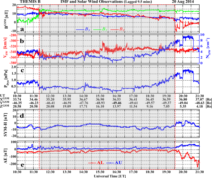
On 20th August 2014, a relatively stable northward IMF condition (IMF Bz > 0 for more than 8 h) occurred with a large duskward component (IMF By ~13 nT), and roughly stable interplanetary conditions with low solar wind speed and density (Fig. 1a–c). The IMF Bx and Bz decreased slowly from 10 to 5 nT over the 8-h period, and the low solar wind speed (around 340 km/s) and number density (around 2 cm[SUP]−3[/SUP]) indicates a very low dynamic pressure of around 0.5 nPa (gray shading in Fig. 1 indicates the interval of interest). These conditions are not favorable for magnetic reconnection at the low-latitude dayside magnetopause[SUP]14,15,16[/SUP], nor for triggering of the K–H instability between the solar wind and magnetosphere in the magnetospheric flank regions[SUP]21,22,23,24,25[/SUP], but are suitable for forming high-latitude dayside auroral spots in the polar cap region[SUP]9,10,11,12,13[/SUP]. The symmetric ring current H index (SYM-H) and auroral electrojet AL and AU indices show non-storm and quiet auroral oval geomagnetic activity during the interval of interest (Fig. 1d, e).
Fig. 1: An overview of the interplanetary conditions and geomagnetic indices on 20th August 2014.

a The IMF components in geocentric solar magnetosphere (GSM) coordinates; b the solar wind number density and speed; c the solar wind dynamic pressure, P[SUB]Dyn[/SUB]; d the provisional SYM-H geomagnetic index (from 6 stations); and e the provisional auroral electrojet geomagnetic indices (from 11 stations): red and blue lines are for AU and AL. Interplanetary data is measured by the Time History of Events and Macroscale Interactions during Substorms (THEMIS)[SUP]44[/SUP] B satellite (in the moon orbit), and has been lagged by 9.5 min to the dayside magnetopause.


Full size image

Observations of the space hurricane

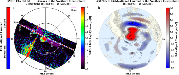
Figure 2a shows an example of auroral observations from the Defense Meteorological Satellite Program (DMSP)[SUP]28[/SUP] F16 Special Sensor Ultraviolet Spectrographic Imager (SSUSI) over the Northern Hemisphere. Around the north magnetic pole, a cyclone-like auroral spot (diameter over 1000 km) with multiple arms and a trend of anti-clockwise rotation is analogically named as space hurricane hereafter (Supplementary Movie 1). The space hurricane was observed by four DMSP satellites, and the observed flows at all the spacecraft magnetic local times (MLTs) were consistent with circular fast flows surrounding the hurricane center (Supplementary Movie 1). It appeared in the polar cap after multiple transpolar arcs disappeared when the interplanetary conditions changed from strongly northward dominated IMF (Bz = ~17 nT, By < 5 nT) with comparable solar wind number density (Nsw = ~4 cm) to the conditions described above (see Fig. 1 and Supplementary Movie 1), similar with the conditions for the appearance of the HiLDA spots[SUP]9,13[/SUP]. There is no conjugate auroral spot in the Southern Hemisphere (Supplementary Movie 2), as expected from the direction of circulation of plasma within the polar cap ionosphere under strong IMF By conditions[SUP]9,12,13,29,30[/SUP]. The space hurricane lasted about 8 h, gradually decayed and merged into the duskside auroral oval around 20:00 UT when the IMF turned southward (see Fig. 1 and Supplementary Movie 1 and 2), same as the disappearance of the HiLDA spots[SUP]9[/SUP]. In addition, the auroral oval (between 70° and 85° MLAT) was generally quiet in the dawn sector while strong arcs persisted in the dusk sector. The field-aligned current (FAC) along the satellite track calculated from the magnetic field measurements of DMSP F16 indicates that the space hurricane was associated with an upward FAC.
Fig. 2: An example of aurora and FACs observations in the polar region of the Northern Hemisphere.

a Aurora in the Lyman–Birge–Hopfield short-band (LBHS) band (wavelength of 140–150 nm), the measured cross-track horizontal ion flows shown in mauve drift vectors perpendicular to the orbit, and the sign of the FACs shown in red and blue color along the satellite track. The aurora is observed by the SSUSI instrument on board the DMSP F16 satellite, the ion flow is measured by the special sensor for ions, electrons, and scintillation (SSIES) and the FAC is calculated from the magnetic field measurement of special sensor microwave (SSM) instrument. These instruments are all on board the DMSP F16 satellite. b The distribution map of the FACs and potential of AMPERE magnetic perturbation data products derived from the Iridium satellites constellation.


Full size image

Around the space hurricane, the Active Magnetosphere and Planetary Electrodynamics Response Experiment (AMPERE) global FAC map (Fig. 2b), estimated from magnetic main-field perturbations observed by Iridium engineering magnetometers[SUP]31,32[/SUP], also shows a spot-like strong upward FAC (red, reaching above 1.5 μAm[SUP]−2[/SUP]) within a negative electric potential cell (contours in Fig. 2b), which is co-located with the space hurricane and confirms that the space hurricane is surrounded by circular convection flow. This circularity or vorticity of the flow includes the flow shears and the flow curvature. The flow shear is approximately constant, but the curvature increases towards the hurricane center, thus forming the spot-like FAC. The FAC spot was surrounded and closed by downward cusp FAC on its equatorward side (blue, reaching about −1.5 μAm[SUP]−2[/SUP], Fig. 2b), so that the combination of hurricane and cusp currents maintained current continuity in the ionosphere[SUP]33[/SUP]. The FAC spot also lasted for more than 8 h (with sometimes a FAC hole developed in the center, see Supplementary Movie 1), and merged into the classical Region 1 FAC about 20:00 UT when the IMF turned southward (see Supplementary Movie 1). Note that upward FACs also appeared to be associated with the duskside auroral arcs, but they are much weaker than the FAC spot.
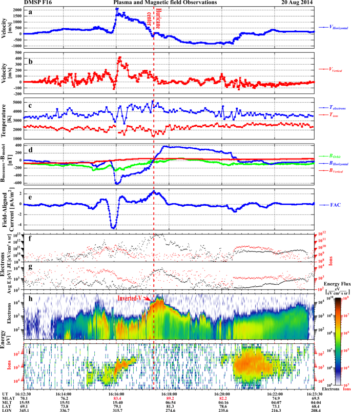
The drift vectors (perpendicular to the spacecraft orbit) in Fig. 2a (mauve) and Fig. 3a show the cross-track horizontal (nearly north-south direction) ionospheric plasma drift from DMSP F16. These show that the space hurricane had zero horizontal flow near its center (the hurricane eye) as well as strong flow shears around the edges: strong sunward flows on its duskside (maximum ~2100 m/s) and antisunward flows on its dawnside (maximum ~800 m/s). Note that there will be a small horizontal offset between the in situ plasma drift data and the auroral images, because the converging magnetic field will cause the flow shears to decrease in horizontal extent from the DMSP in situ observation altitude (860 km) to the auroral mapping altitude (110 km, Fig. 2a). These flow shears give a clockwise circulation of ionospheric flow, which appears opposite to the rotation trend that might be inferred from the multiple arms of the auroral spot. This indicates an interesting difference from tropospheric hurricanes that is discussed latter.
Fig. 3: The in-situ plasma and current conditions for the orbit of DMSP F16 shown in Fig. 2a.

a, b The cross-track horizontal and vertical ion flow; c electron and ion temperature; d the three components of the measured magnetic field subtracted by the modeled magnetic field from the International Geomagnetic Reference Field (IGRF) model[SUP]45[/SUP]; e the calculated field-aligned current; f the precipitating electron and ion total energy flux, JE; g the electron and ion average energy, Avg E; h the precipitating electron energy flux, and i the precipitating ion energy flux. Data in ac are measured by SSIES, data in d, e are observed or calculated from the magnetic field measurement of SSM, and data in fi are measured by the Special Sensor for Precipitating Particles (SSJ4) instrument on board the DMSP F16 satellite.


Full size image

Figure 3b–e shows that the space hurricane is also associated with ion upflows, enhanced electron temperature (about 1000 K enhancement), a negative-to-positive bipolar magnetic structure (implying a circular magnetic field perturbation) and strong upward field-aligned currents (consistent with the AMPERE FAC observations). Within the space hurricane, the total energy flux (JE) and the average energy of the precipitating electrons were significantly increased (Fig. 3f, g), resulting in a time integrated JE (ΣJE) up to 2.48 × 10[SUP]14[/SUP] eV/(cm[SUP]2[/SUP]·sr) from 16:16:58 to 16:18:51 UT, which is about 91.49% of the ΣJE (2.71 × 10[SUP]14[/SUP] eV/(cm[SUP]2[/SUP]·sr)) for the whole polar pass (see Tables 1 and 2). The ΣJE (2.71 × 10[SUP]14[/SUP] eV/(cm[SUP]2[/SUP]·sr)) is about 10 times higher than that for a polar pass without a space hurricane also under a geomagnetic quiet condition (see Tables 1 and 2 for the DMSP pass from 08:54:22 to 09:11:24 UT on 21 June 2010). It is about 4.6 times higher than that for a pass under typical southward IMF conditions during non-storm time (see Tables 1 and 2 for the DMSP pass from 16:26:00 to 16:46:00 UT on 08 October 2014). Furthermore, it is only about 4.6 times smaller than the ΣJE of a pass during the main phase of the first super geomagnetic storm of solar cycle 24 which had intense solar wind driving and strong southward IMF (see Tables 1 and 2 for the pass from 23:14:00 to 23:44:00 UT on 17 March 2015). The space hurricane has an average energy flux about 5.5 times higher than its own whole polar pass, and this whole pass is about 15.1 times higher than the pass for the typical quiet case, about 8.3 times higher than the pass for the typical southward IMF case, and even 3.2 times higher than the super storm case (see Table 2). These means that the average electron energy flux in the space hurricane (2.2 × 10[SUP]12[/SUP] eV/(cm[SUP]2[/SUP]·s·sr)) is much higher than that during substorm expansion[SUP]34[/SUP], but is comparable to that during super storms (sometimes exceeding 10[SUP]13[/SUP] eV/(cm[SUP]2[/SUP]·s·sr) during strikingly super storms)[SUP]35,36[/SUP]. Note that the large electron precipitation flux during substorms and storms is within the auroral oval, which is located at much lower latitudes than the space hurricane. Table 2 also shows that the average energy flux in the space hurricane (2.2 × 10[SUP]12[/SUP] eV/(cm[SUP]2[/SUP]·s·sr)) is about 28.8 times higher than that in the auroral oval (7.8 × 10[SUP]10[/SUP] eV/(cm[SUP]2[/SUP]·s·sr)) and 71.7 times higher than that in the diffuse aurora region (3.1 × 10[SUP]10[/SUP] eV/(cm[SUP]2[/SUP]·s·sr)) during the same pass (see Fig. 3g). The space hurricane also has the highest maximum and average energy in the magnetic pole region compared to the values during typical quiet and super storm times in the same region (see Table 2). These indicate that the space hurricane leads to large and rapid deposition of energy and flux into the polar ionosphere during an otherwise extremely quiet geomagnetic condition, suggesting that current geomagnetic activity indicators do not properly represent the dramatic activity within space hurricanes, which are located further poleward than geomagnetic index observatories.
Table 1 The average values of the interplanetary and geomagnetic conditions for four typical conditions.Full size table

Table 2 The energy flux and average energy of the precipitating electrons observed by SSJ4 instrument onboard the DMSP satellites under different conditions.Full size table

Clear electron inverted-V acceleration appeared within the space hurricane with ~10 keV energy electron precipitation near the hurricane center and ~1 keV energy electron precipitation around the edge (Fig. 3g, h), the amount of electron energization increasing with increasing upward FAC strength due to an increasing field-aligned potential drop. Under this quasi-steady condition with uniform ionospheric conductivity due to sunlit conditions, the large-scale, stronger FACs near the hurricane center should be connected to convergent ionospheric Pedersen currents caused by the combination of the velocity shear and the curvature of the circular flow increasing towards the hurricane center, inferring that a FAC spot or funnel with circular fast flows appears in the electron source region. Note that there is almost no ion precipitation in the space hurricane area (Fig. 3i) and no conjugate auroral structure in the Southern Hemisphere (see Supplementary Movie 2), same as for HiLDA spots[SUP]9,12[/SUP]. These observations indicate that the space hurricane contains accelerated electron precipitation that likely originated from the open-magnetic field, high-latitude lobe region of the magnetosphere.
The observed features and formation conditions of the space hurricane are almost the same as for the HiLDA spots from coincident observations by the IMAGE and FAST satellites[SUP]9,10,11,12,13[/SUP]. This indicates that HiLDA spot may be the same phenomenon as the space hurricane in the polar cap region. However, the important characteristics of the space hurricane identified here, i.e., a cyclone-shaped aurora, a strong circular horizontal plasma flow with shears, and a nearly zero-flow center, could not be identified in the previous HiLDA observations[SUP]9,10,11,12,13[/SUP] due to the relatively low spatial resolution in that auroral image data and the lack of coincident ionospheric plasma drift measurements.
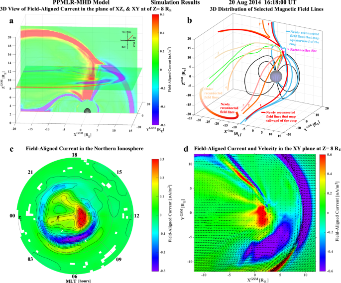
Data-driven simulation

The formation of space hurricane is further investigated by simulation using a high-resolution 3-D global magnetohydrodynamics (MHD) code, piecewise parabolic method[SUP]37[/SUP] with a Lagrangian remap to MHD (PPMLR-MHD)[SUP]38,39[/SUP], which uses the measured interplanetary conditions as inputs. Figure 4a shows a 3-D view of simulated FACs in the GSM X–Z plane and X–Y plane at Z = 8 R[SUB]E[/SUB]. The Sun is on the right. The magnetopause boundary is characterized by a narrow downward FAC belt (purple) on the dayside, and by a narrow upward FAC belt (red) on the dawn flank and in the high-latitude lobe region. In the center of Fig. 4a, a strong upward FAC funnel appears to nearly link the polar ionosphere to the inner edge of the high-latitude magnetopause FAC belt. The 3D topology of selected magnetic field lines suggests that there is magnetic reconnection occurring between the IMF and Earth’s magnetic field at the dayside magnetopause around both the tailward (red lines) and equatorward (light blue lines) field lines of the cusp (Fig. 4b). The reconnected open field lines link to the northern hemisphere, and tend to move dawnward and then tailward from the morning side to the afternoon side in the high-latitude lobe region (highlighted by the colored and numbered field lines and an arrowed curve in Fig. 4b). Figure 4c shows the upward FAC closing through a strong downward FAC band on the dawn side that appears to connect to the downward FAC belt of the dayside magnetopause. These are remarkably consistent with the AMPERE and DMSP FAC observations. The funnel of FAC appears as a spot with several arms and a trend of anti-clockwise rotation (Fig. 4d, Supplementary Movie 3 and Supplementary Fig. 1), consistent with the DMSP SSUSI auroral and plasma observations. These upward FACs (both from the simulation and observations) cause magnetic field-aligned acceleration of magnetospheric electrons (probably through the Knight current–voltage process to keep current continuity[SUP]11,25,33,40,41[/SUP]) that precipitate into the polar ionosphere and generate the hurricane structure in the aurora. Note that a pair of current sheets can be seen on the duskside of the spot, at ~18–21 MLT, which appear to correspond with the duskside auroral arcs seen in the DMSP SSUSI images. These consistencies provide strong evidence that the PPMLR-MHD model captures the key physical processes for these northward IMF conditions.
Fig. 4: 3-D and 2-D view of simulated FACs and selected magnetic field lines by the PPMLR-MHD code at the center time of the example in Fig. 2a.

a 3-D view of the simulated FACs in the GSM X–Z plane, and the X–Y plane at Z = 8 R[SUB]E[/SUB]; b 3-D distribution of selected magnetic field lines with magenta crosses representing the reconnection sites and the numbered field lines in red to light brown representing the newly to old evolution of the reconnected field lines that also highlighted by the thick arrowed color curve; c 2-D distribution of simulated FACs in the northern polar ionosphere with FAC contour lines, and d close-up view of the 2-D distribution of FACs and plasma velocity vectors in the X–Y plane at Z = 8 R[SUB]E[/SUB].


Full size image


Discussions

Formation of the space hurricane

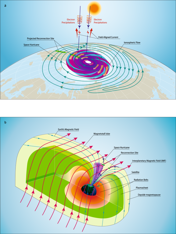
Figure 5a schematically summarizes the main observational features of the space hurricane. A large cyclone-shaped auroral spot is shown with a nearly zero-flow center and strong circular horizontal plasma flow, shears, electron precipitation, and upward FACs. These features resemble a typical hurricane in the lower atmosphere. A circular large convection lobe-cell of the space hurricane as seen within the ionosphere is embedded within the normal afternoon convection cell, which is formed due to high-latitude lobe reconnections[SUP]9,12,14,26,29,30,42[/SUP].
Fig. 5: Schematic of the space hurricane and its formation mechanism during an extremely quiet geomagnetic condition with northward IMF and a dominant By component.

a Schematic of a space hurricane in the northern polar ionosphere. The magenta cyclone-shape auroral spot with brown thick arrows of circular ionospheric flows represents the space hurricane with a light green background showing the downward FACs. Convection streamlines are in blue with green thick crossed bars that shows the projected magnetic reconnection sites at the dayside magnetopause around equatorward and tailward (lobe) boundary of the cusp[SUP]29,30[/SUP]. The vertical dark blue lines represent the Earth’s magnetic field lines with electron precipitations and FACs. The sun is on the top representing the polar ionosphere is under sunlight conditions during the interval of interest. b Schematic of the 3-D magnetosphere when a space hurricane happened. Different color shadings represent different regions of the magnetosphere. The shaded magenta funnel shows the space hurricane in the magnetosphere. Red, black and blue curves with arrows are the interplanetary magnetic field lines, Earth’s magnetic field lines, and newly reconnected Earth’s magnetic field lines. The green thick bars represent the reconnection sites. The yellow curve with a satellite icon shows the satellite orbit. In this case, magnetopause reconnection can take place at the dayside magnetopause around equatorward and tailward (lobe) boundary of the cusp[SUP]29,30[/SUP]. Due to a steady high-latitude lobe reconnection, a funnel (space hurricane) formed just poleward of the cusp region (b), and a large ionospheric convection lobe-cell with strong circular horizontal plasma flow inside the normal afternoon convection cell (a).


Full size image

During a northward IMF with a dominant By component, magnetic reconnection occurs between IMF and the Earth’s open-magnetic field lines tailward of the cusp in the afternoon sector[SUP]9,12,14,26,29,30[/SUP] (high-latitude lobe reconnections, Fig. 4b and Supplementary Fig. 2 and Supplementary Movie 4). The newly reconnected open field lines are draped by the solar wind to move dawnward and then tailward from the morning side to the afternoon side in the high-latitude lobe region[SUP]26,29[/SUP]. During their dawnward and tailward motion, an elongated FAC sheet forms due to the flow shear, and the magnetosheath ions precipitate into the cusp ionosphere along field lines to give the downward FACs (like traces of dropping sands from a moving hourglass). In order to maintain current continuity in the ionosphere, the system sets up an upward FAC with a parallel potential that accelerates the existing electrons into the ionosphere and creates an arm of the auroral spot[SUP]12,33[/SUP] observed by DMSP F16 in Fig. 2a and shown in Fig. 5a.
When the lobe reconnection is pulsed or quasi-steady for an extended period of time (e.g., several hours), the reconnected open field lines will gradually return to their previous positions and participate in a new cycle of magnetic reconnection (Supplementary Movie 4), which will eventually form a cyclone-shaped funnel of FAC (see Fig. 5b) with multiple FAC arms and a clockwise circulation of the plasma flow, due to the pressure gradient and magnetic stresses on both sides of the funnel for completing the FACs and the flow shear and curvature of the circular flow. Inside the funnel, a corkscrew magnetic field forms with circular flow and upward FACs, which accelerate electrons that precipitate into the ionosphere[SUP]12,25,41[/SUP] and create the auroral spot with multiple arms as observed by DMSP F16 in Fig. 2a. In other words, the auroral arms represent the trace of the footprints of the reconnected magnetic field lines, and shows an illusional trend of anti-clockwise rotation, which is opposite to the flow circulation and different from tropospheric hurricanes. This funnel becomes the most efficient channel to transfer the solar wind/magnetosphere energy and momentum into the ionosphere, and to accelerate terrestrial ions that escape into the magnetotail or interplanetary space, during periods of very low solar wind density and speed and a northward IMF with a dominant By component. The footprint of these field line trajectories forms a circular large ionospheric convection lobe-cell with strong embedded circular horizontal plasma flow inside the normal afternoon convection cell[SUP]9,12,26,29,30,42[/SUP]. Within this lobe-cell, strong radial electric fields point toward the cell center leading to a strong upward FAC that maintains current continuity in the ionosphere[SUP]25,33,41[/SUP]. Strong magnetic field-aligned electric fields are required to give the strong FAC, accelerating electrons up to ~10 keV that precipitate and form the auroral signature of the space hurricane[SUP]25,41[/SUP]. These observations indicate that there is a significant difference between the drivers of atmospheric and space hurricanes. Hurricanes or tropical cyclones require strong driving from below (latent heat flux due to rising moist air over a warm ocean), while space hurricanes occur under an extremely quiet interplanetary condition (low solar wind speed, density, and northward interplanetary magnetic field). The extremely quiet interplanetary condition results in efficient lobe reconnection which leads to the formation of the space hurricane. The space hurricane opens a rapid energy transfer channel from space to the ionosphere and thermosphere, and would be expected to lead to important space weather effects like increased satellite drag, disturbances in High Frequency (HF) radio communications, and increased errors in over-the-horizon radar location, satellite navigation, and communication systems[SUP]15,43[/SUP]. The space hurricane is likely a universal phenomenon, occurring at other magnetized bodies in the universe (planets and their moons, etc.). The process may also be important for the interaction between interstellar winds and other solar systems throughout the universe.


Methods

PPMLR-MHD model

The PPMLR-MHD model is a 3-D MHD model, which is based on an extension of the piecewise parabolic method[SUP]37[/SUP] with a Lagrangian remap to MHD[SUP]38,39[/SUP]. It is designed particularly for the solar wind–magnetosphere–ionosphere system[SUP]22,23,24[/SUP]. The model possesses a high resolution for capturing MHD shocks and discontinuities and a low numerical dissipation for examining possible instabilities inherent in the system[SUP]22[/SUP].
A Cartesian coordinate system has been used in the model with the Earth’s center at the origin with X-axis pointing towards the Sun, Y-axis towards the dawn-dusk direction, and Z-axis towards the north. The size of the numerical box extends from 30 R[SUB]E[/SUB] to –100 R[SUB]E[/SUB] along the Sun-Earth line and from −50 R[SUB]E[/SUB] to 50 R[SUB]E[/SUB] in Y and Z directions, with 320 × 320 × 320 grid points and a minimum grid spacing of 0.15 R[SUB]E[/SUB]. In order to avoid the complexities associated with the plasmasphere and large MHD characteristic velocity from the strong magnetic field, an inner boundary of radius 3 R[SUB]E[/SUB] is set for the magnetosphere[SUP]24[/SUP]. For allowing an electrostatic coupling process introduced between the ionosphere and the magnetospheric inner boundary, the model imbeds an electrostatic ionosphere shell with height-integrated conductance. An approximately dipole field has been used as the Earth’s magnetic field with a dipole moment of 8.06 × 10[SUP]22[/SUP] A/m in magnitude. For the current event, the model is run to solve the whole system by using the measured interplanetary conditions as inputs.


Data availability

The THEMIS B solar wind and IMF data are available on http://themis.ssl.berkeley.edu/data/themis/thb/l2/esa/ and http://themis.ssl.berkeley.edu/data/themis/thb/l2/fgm/, respectively. The SYM-H and AE indices data is available on http://wdc.kugi.kyoto-u.ac.jp/dstdir/. The DMSP SSUSI and particle data is available on https://ssusi.jhuapl.edu/gal_AUR, http://sd-www.jhuapl.edu/Aurora/ and ftp://ftp.ngdc.noaa.gov/STP/satellite_data/, respectively. The AMPERE field-aligned current is available on http://ampere.jhuapl.edu/rBrowse/index.html. The 3D PPMLR-MHD simulation data is available on https://doi.org/10.5281/zenodo.4395721 with a separate DOI of https://doi.org/10.5281/zenodo.4395721.

Download citation
 

St. Phatty

Active member
Well it's been Spring in Southern Oregon for about 2 months.

We are going to have a full crop of Long Grass this year.

When I was up on the hill behind my house about 3 weeks ago, the grass was 4 inches long. And we've had a lot of sun since then.

At the beginning it tends to grow exponentially (sort of like Cannabis), and then slow down.

Basically increasing in size 50% every 1 or 2 weeks.

If we get rain in April, it will re-fill the soil and keep growing through the end of May.
Then it dies and becomes Fuel for fires.

In my case it's about 3 acres of grass, on a hillside, sort of staring at me all summer long, warning me to be careful about fire.

It is going to a serious Fire year.
 

igrowone

Well-known member
Veteran
time to wake up the thread in its new home, see how it goes
any how the NSIDC has restored its proper processing of arctic ice
and there was indeed one hell of a dip around the Texas freeze up
a very strong high pressure system developed in the arctic at the time
result was a freezing Texas and a noticeable chunk of ice missing up north
and it appears the maximum has been reached, well below normal but not a record low max
edit: pics are not cooperating, figure it out eventually
 

Attachments

  • N_daily_extent.jpg
    N_daily_extent.jpg
    34.3 KB · Views: 51
  • N_iqr_timeseries.jpg
    N_iqr_timeseries.jpg
    53.7 KB · Views: 43

igrowone

Well-known member
Veteran
the melt season looks like it has arrived up at the northern places
a well below normal ice making season at the arctic, but they're all below normal seasons now
hopefully the time series picture is clear in this post with the February reduction
that was dramatic, what you feel down here is getting more affected from what's going on up there
 

Attachments

  • photo2033001.jpg
    photo2033001.jpg
    34.5 KB · Views: 36
  • photo2033002.jpg
    photo2033002.jpg
    54.2 KB · Views: 44

igrowone

Well-known member
Veteran
greetings friends
it's the first evening of summer, what could be better than to look at some ice pictures?
for some members some cool thoughts might not hurt, brutal heat out west
anyhow here's the story
near record low ice in the arctic for this time of year
but then when isn't near record lows? more often than not, it is
 

Attachments

  • photo2052902.jpg
    photo2052902.jpg
    70.8 KB · Views: 41
  • photo2052903.jpg
    photo2052903.jpg
    121.8 KB · Views: 42
  • photo2052904.jpg
    photo2052904.jpg
    107 KB · Views: 39

HempKat

Just A Simple Old Dirt Farmer
Veteran
118 degrees F today in Canada!
Highest temperature ever recorded in this country.

I don't know if this would apply to that particular temperature reading but I was recently watching a discussion of climate change and how it might be impacting the ocean current known as the "Great Conveyor Belt". In that discussion one of the people mentioned a recent reading of 119 degrees F in the Arctic. The other person clarified that though by pointing out it was a reading of one particular point by satellite which can b misleading and that the more correct expression of atmospheric temperature in the Arctic is somewhere in the 80F range. Still way too high but more realistic.
 

igrowone

Well-known member
Veteran
for those that watch this thread but disagree with the premise
these temps should get your attention
probably won't because some seem incapable of change, not being able to change is not a survival strength
 
Top