What's new
  • As of today ICMag has his own Discord server. In this Discord server you can chat, talk with eachother, listen to music, share stories and pictures...and much more. Join now and let's grow together! Join ICMag Discord here! More details in this thread here: here.

Have you looked at the North Pole lately?

trichrider

Kiss My Ring
Veteran
My belly sticks out too far.....:dance:
have you tried watercress sandwiches?
i have to tie my beard in knots to see my belly.


The moon controls the release of methane in Arctic Ocean

High tides may even counter the potential threat of submarine methane release from the warming Arctic.

Text: Maja Sojtaric

It may not be very well known, but the Arctic Ocean leaks enormous amounts of the potent greenhouse gas methane. These leaks have been ongoing for thousands of years but could be intensified by a future warmer ocean. The potential for this gas to escape the ocean, and contribute to the greenhouse gas budget in the atmosphere, is an important mystery that scientists are trying to solve.
The total amount of methane in the atmosphere has increased immensely over the past decades, and while some of the increase can be ascribed to human activity, other sources are not very well constrained.
A recent paper in Nature Communications even implies that the moon has a role to play.


Small pressure changes affect methane release

The moon controls one of the most formidable forces in nature – the tides that shape our coastlines. Tides, in turn, significantly affect the intensity of methane emissions from the Arctic Ocean seafloor.
“We noticed that gas accumulations, which are in the sediments within a meter from the seafloor, are vulnerable to even slight pressure changes in the water column. Low tide means less of such hydrostatic pressure and higher intensity of methane release. High tide equals high pressure and lower intensity of the release” says co-author of the paper Andreia Plaza Faverola.
“It is the first time that this observation has been made in the Arctic Ocean. It means that slight pressure changes can release significant amounts of methane. This is a game-changer and the highest impact of the study.” Says another co-author, Jochen Knies.


New methods reveal unknown release sites

Plaza Faverola points out that the observations were made by placing a tool called a piezometer in the sediments and leaving it there for four days.
recovery-piazomenter-cruise-1024x625.png
Retrieving the pressure tool, piezometer, which was monitoring the methane release from the ocean floor sediments. Photo: Screenshot from video. P.Domel.
It measured the pressure and temperature of the water inside the pores of the sediment. Hourly changes in the measured pressure and temperature revealed the presence of gas close to the seafloor that ascends and descends as the tides change. The measurements were made in an area of the Arctic Ocean where no methane release has previously been observed but where massive gas hydrate concentrations have been sampled.
“This tells us that gas release from the seafloor is more widespread than we can see using traditional sonar surveys. We saw no bubbles or columns of gas in the water. Gas burps that have a periodicity of several hours won’t be identified unless there is a permanent monitoring tool in place, such as the piezometer.” Says Plaza Faverola
flares-ocean-floor-andreia-plaza-faverola-1024x579.png
Methane release can be seen as flares rising from the ocean floor. But the release is not always visible using the usual methods. Screenshot from data visualization by Andreia Plaza Faverola.

These observations imply that the quantification of present-day gas emissions in the Arctic may be underestimated. High tides, however, seem to influence gas emissions by reducing their height and volume.

“What we found was unexpected and the implications are big. This is a deep-water site. Small changes in pressure can increase the gas emissions but the methane will still stay in the ocean due to the water depth. But what happens in shallower sites? This approach needs to be done in shallow Arctic waters as well, over a longer period. In shallow water, the possibility that methane will reach the atmosphere is greater.” Says Knies.


May counteract the temperature effects

High sea-level seems thus to influence gas emissions by potentially reducing their height and volume. The question remains whether sea-level rise due to global warming might partially counterbalance the effect of temperature on submarine methane emissions.
“Earth systems are interconnected in ways that we are still deciphering, and our study reveals one of such interconnections in the Arctic: The moon causes tidal forces, the tides generate pressure changes, and bottom currents that in turn shape the seafloor and impact submarine methane emissions. Fascinating!” says Andreia Plaza Faverola


The paper is the result of a collaboration between CAGE and Ifremer under the project SEAMSTRESS – Tectonic Stress Effects on Arctic Methane Seepage
Ref: Nabil Sultan, Andreia Plaza-Faverola, Sunil Vadakkepuliyambatta, Stefan Buenz & Jochen Knies. Impact of tides and sea-level on deep-sea Arctic methane emissions. Nature Communications. https://doi.org/10.1038/s41467-020-18899-3


https://cage.uit.no/2020/12/11/the-moon-controls-the-release-of-methane-in-arctic-ocean/
 

trichrider

Kiss My Ring
Veteran
Russian Freighter Caught in the Ice in Siberian Arctic

Bosphorus-observer-sparta-III.8780a1.jfif


Sparta III on a previous voyage in 2018 (File image courtesy Bosphorus Observer)

By The Maritime Executive 12-21-2020 11:15:00


The Russian con/ro Sparta III has gotten stuck in the ice in the Arctic waters of Yenisey Gulf, an inlet on the Kara Sea, according to state news outlet TASS.


According to TASS, the vessel became caught in the ice on December 13. She ran low on food and water as the crew attempted to break out, a shipping source told TASS, and unspecified equipment froze up.


The crew's effort to free the vessel has not shown signs of success, and AIS tracking shows that Sparta III remains stationary, attended by one offshore tug. With the Siberian winter setting in, operator Oboronlogistics has called for heavy icebreaker assistance.


"In the coming days, a nuclear icebreaker will be dispatched to escort the vessel to a safe area for navigation. The vessel has the necessary supplies of food and lubricants, communication with the captain is maintained," Oboronlogistics told TASS. "There is no threat to the life of the ship's crew members."


Sparta III is a geared con/ro built in Germany to Germanischer Lloyd ice class E3 (roughly equivalent to 1A) in 2009. She was acquired in 2017, and she is now the largest vessel in the fleet of Oboronlogistics, a firm founded to provide transport services for the Russian military. She was getting under way on a voyage from Dudinka to Arkhangelsk at the time of the incident, TASS reported.
Oboronlogistics also holds the unique rail-ferry contract for operations between Baltysk and the exclave of Kaliningrad, an isolated outpost between Poland and Lithuania on the Baltic.


https://www.maritime-executive.com/article/russian-freighter-caught-in-the-ice-in-siberian-arctic
 

trichrider

Kiss My Ring
Veteran
The Cooler Sister Returns


November 25, 2020JPEG


Though air and sea temperatures worldwide have been quite warm in 2020, the eastern and central Pacific Ocean recently grew milder with the return of La Niña, the cooler sister to El Niño.


La Niña brings cool water up from the depths of the eastern tropical Pacific, a pattern that energizes easterly trade winds and pushes warm surface waters back toward Asia and Australia. With this see-sawing of the heat and moisture supply across the Pacific, global atmospheric circulation and jet streams shift.


During La Niña events, weather patterns typically grow warmer and drier across the southern United States and northern Mexico, noted Josh Willis, a climate scientist and oceanographer at NASA’s Jet Propulsion Laboratory (JPL). Cooler and stormier conditions often set in across the Pacific Northwest of Canada and the U.S. Clouds and rainfall become more sporadic over the central and eastern Pacific Ocean, which can lead to dry conditions in Brazil, Argentina, and other parts of South America. In the western Pacific, rainfall can increase dramatically over Indonesia and Australia. La Niña also can coincide with active Atlantic hurricane seasons, as it did this year.


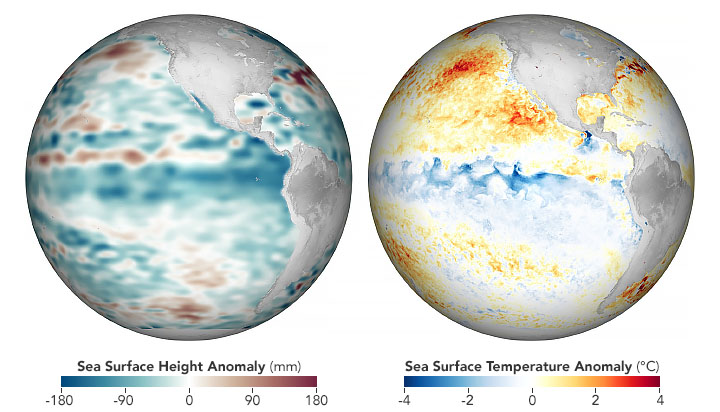
The maps above show conditions across the central and eastern Pacific Ocean as observed on November 25, 2020, and analyzed by JPL scientists.


The globe on the left depicts sea surface height anomalies measured by the Jason-3 satellite. Shades of blue indicate sea levels that were lower than average; normal sea-level conditions appear white; and reds indicate areas where the ocean stood higher than normal. The expansion and contraction of the surface is a good proxy for ocean temperatures because warmer water expands to fill more volume, while cooler water contracts.


The second globe shows sea surface temperature (SST) data from the Multiscale Ultrahigh Resolution Sea Surface Temperature (MUR SST) project. MUR SST blends measurements of sea surface temperatures from multiple NASA, NOAA, and international satellites, as well as ship and buoy observations. (Scientists also use instruments floating within the sea to project underwater temperatures.)


“This 2020 La Niña seems to be peaking,” said Bill Patzert, a retired oceanographer and climatologist from JPL. “It was a bit of a surprise because it evolved quickly and unlike many previous La Niña events it was not preceded by its warm sibling, El Niño.”


This La Niña fits into a larger climate pattern that has been going on for nearly two decades—a cool (negative) phase of the Pacific Decadal Oscillation (PDO). During most of the 1980s and 1990s, the Pacific was locked in a PDO warm phase, which coincided with several strong El Niño events. But since 1999, a cool phase has dominated.


“With a few notable exceptions, the PDO has been negative for most of the past 20 years, and that is favorable for La Niña,” said Willis. “Drought patterns across the American Southwest over the past two decades fit with this trend.”


“The re-emergence of this large-scale PDO pattern tells us there is much more than an isolated La Niña occurring in the Pacific Ocean,” Patzert added. “These shifts can trigger decade or longer droughts in some regions and damaging floods elsewhere.”


In recent reports issued by the NOAA Climate Prediction Center and the World Meteorological Organization, climatologists forecasted that the current La Niña should last through the 2020-21 northern hemisphere winter.


In late November, water temperatures in the central Pacific Ocean were roughly 1.4 degrees Celsius below the long-term average. A La Niña event is declared when average surface water temperatures stay at least 0.5° Celsius below normal in the Niño 3.4 region of the tropical Pacific (from 170° to 120° West longitude) for three months.


Later in 2021, scientists will have a new tool for observing La Niñas and other trends in global sea level. Following the successful launch of the Sentinel-6 Michael Freilich satellite in November 2020, scientists released some of the first measurements from the new ocean-observing satellite. Engineers and scientists are now calibrating instruments and analyzing data to make sure it correlates properly with long-term records.


“Christmas came early this year,” noted Willis, who is also NASA’s project scientist for the mission. “And right out of the box, the data look fantastic.”


https://earthobservatory.nasa.gov/images/147703/the-cooler-sister-returns
 

trichrider

Kiss My Ring
Veteran
Russia Reopens Soviet-Era Lab To Develop Weapons For Arctic Sub-Zero Conditions

picture-5.jpg
by Tyler Durden

Thursday, Dec 24, 2020 - 20:00
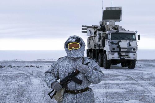
Russia is believed to be greatly expanding and beefing up its ability to wage warfare in extreme cold and icy conditions after it was announced Thursday that a Soviet-era laboratory has been reconstituted and newly opened in order to test weapons in Arctic weather.
"The Central Scientific-Research Institute for Precision Machine Engineering, that makes weapons for Russia's military, said it had restored testing chambers to simulate extreme conditions," Reuters reports of the facility which was shut down since the the end of the Soviet Union in 1991.
arcticlab.jpg
Via AP


The Institute issued a press release saying "the certification is the final step towards restoring this unique technological capability that had been lost after the fall of the USSR." The complex's test chambers will actually be able to simulate a variety of conditions to also include extreme heat as well as wet weather.

Russian media cited a senior technician, Sergei Karasev, as detailing further:
He said the test site will begin work on a number of weapons, including rifles, specially-made grenade launchers and small caliber cannons in "extreme temperatures" as low as minus 60 degrees.
The conditions are designed to mimic environments like the Arctic, but the facility will also recreate a number of other potential battlefields. Tests to see whether weapons can withstand tropical climes will be carried out in a combined heat and rain chamber, while a dust chamber mimics the pressures that deserts exert on firing mechanisms.
Typically when temperatures reach such extremes as minus 60 degrees Celsius, cars and machinery break down unless they are specially outfitted to operate in the extreme cold.
Without extensive protections even a person's face can become frostbitten in just minutes after being exposed to such temperatures.
In remote locations like Russia's Sakha Republic (Yakutia) for example, schools, colleges and public places will only stay open until temperatures as low as -52°C, but upon reaching that limit will shut down for safety reasons.
Much standard military equipment would also not work properly in these conditions, hence Russia's focus on developing and testing weapons that are optimal in Arctic conditions. The plan is to also simulate how battlefield tactics would change in extreme and varied conditions.


https://www.zerohedge.com/geopoliti...-lab-test-weapons-extreme-sub-zero-conditions
 

trichrider

Kiss My Ring
Veteran
"Bomb Cyclone" Detonates Over Alaska's Aleutian Islands Unleashing Hurricane Force Winds

picture-5.jpg
by Tyler Durden

Friday, Jan 01, 2021 - 18:35
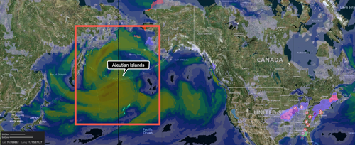
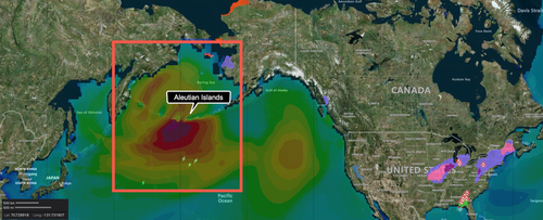
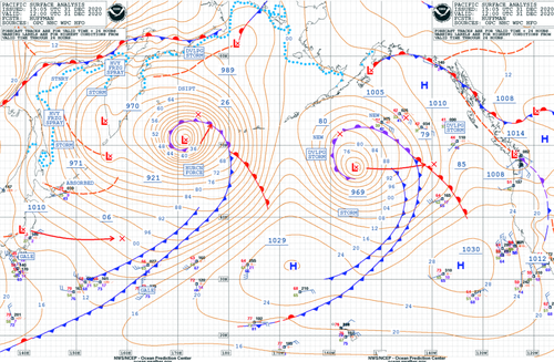
A monster storm explosively intensified in the northern Pacific near Alaska's Aleutian Islands on New Year's Eve, battering the region with hurricane-force winds, heavy seas, and torrential rains, according to Reuters.
"It's the most intense storm ever recorded in the North Pacific, excluding typhoons," said Brian Brettschneider, a National Oceanic and Atmospheric Administration (NOAA) scientist with the National Weather Service (NWS).
The storm is classified as a "bomb cyclone" after meteorologists recorded barometric pressure of 921 millibars, a record-low reading for the region, equivalent to the center of a Category 4 hurricane.
Wind Speed Map

2021-01-01_14-42-15.png

In western Aleutians, waves greater than 50 feet were seen with winds more than 80 mph, or on par with a Category 1 hurricane. The islands are barely populated, and the storm poses a limited risk to humans, but the area is a heavily used commercial shipping route between Asia and the US.
Wave Height Analysis
2021-01-01_14-46-47.png

Brettscheneider said the real threat of the storm is aircraft or vessels in the region.
Unlike hurricanes, these large and powerful storms go unnamed," Capital Weather Gang's weather expert Jeff Halverson wrote back in 2015.
The National Weather Service's (NWS) Ocean Prediction Center (OPC) tweeted Thursday night:
"Here is the latest surface analysis showing a strong storm with winds to #hurricaneforce moving toward the Bering Sea. The central pressure is 921 MB making it one of the strongest storms to ever impact the North Pacific. Winds are expected to reach 95 kts near the low center!"
2021-01-01_13-49-07.png

Satellite imagery of the storm is impressive.
Late last night, NWS-OPC tweeted:
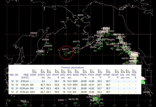
"The #HurricaneForce low near the Aleutians continues to produce extreme conditions. Buoy 46071 (circled in red) is observing seas greater than 50 ft. Note in the insert the 58 ft measurement."
2021-01-01_13-51-15.png

The jet stream is likely to carry the weather disturbance into the Pacific Northwest next week.
 

igrowone

Well-known member
Veteran
recent news - 2020 ties 2016 for warmest year in the current climate record
but 2020 was a la nina year where the earth's surface temperature takes a dip
count on a toasty 2021, not to mention 2022 ...
 

igrowone

Well-known member
Veteran
View Image


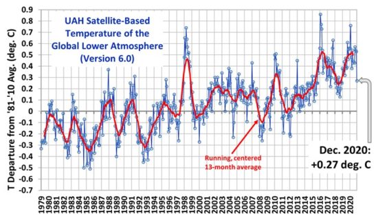
UAH Global Temperature Update for December 2020: +0.27 deg. C

January 2nd, 2021 by Roy W. Spencer, Ph. D. The Version 6.0 global average lower tropospheric temperature (LT) anomaly for December, 2020 was +0.27 deg. C, down substantially from the November, 2020 value of +0.53 deg. C.


https://www.drroyspencer.com/2021/01/uah-global-temperature-update-for-december-2020-0-27-deg-c/
not familiar with the reliability of this reference
but accepting it as true is not a great thing
it simultaneously illustrates just how warm the rest of the year was
and dramatic changes in temperature do not bode well
but does parallel other dramatic climatic events of 2020
 

trichrider

Kiss My Ring
Veteran
Applications Aeolus shines a light on polar vortex
04/02/2021 2719 views 79 likes
ESA / Applications / Observing the Earth / Aeolus
As this winter’s polar vortex currently sends extreme icy blasts of Arctic weather to some parts of the northern hemisphere such as the northeast of the US, scientists are using wind information from ESA’s Aeolus satellite to shed more light on this complex phenomenon.

The polar vortex is a huge mass of frigid air high above the North Pole in the polar stratosphere. It is surrounded by a strong jet of air swirling counter-clockwise along the vortex’s boundary. The vortex tends to be much stronger in the winter, keeping bitter cold air locked in around the Arctic.
However, sometimes the vortex can weaken, become distorted or even split into two and meander further south, affecting the weather and jetstream further down in the troposphere, potentially bringing unusually cold weather and snow to lower latitudes.

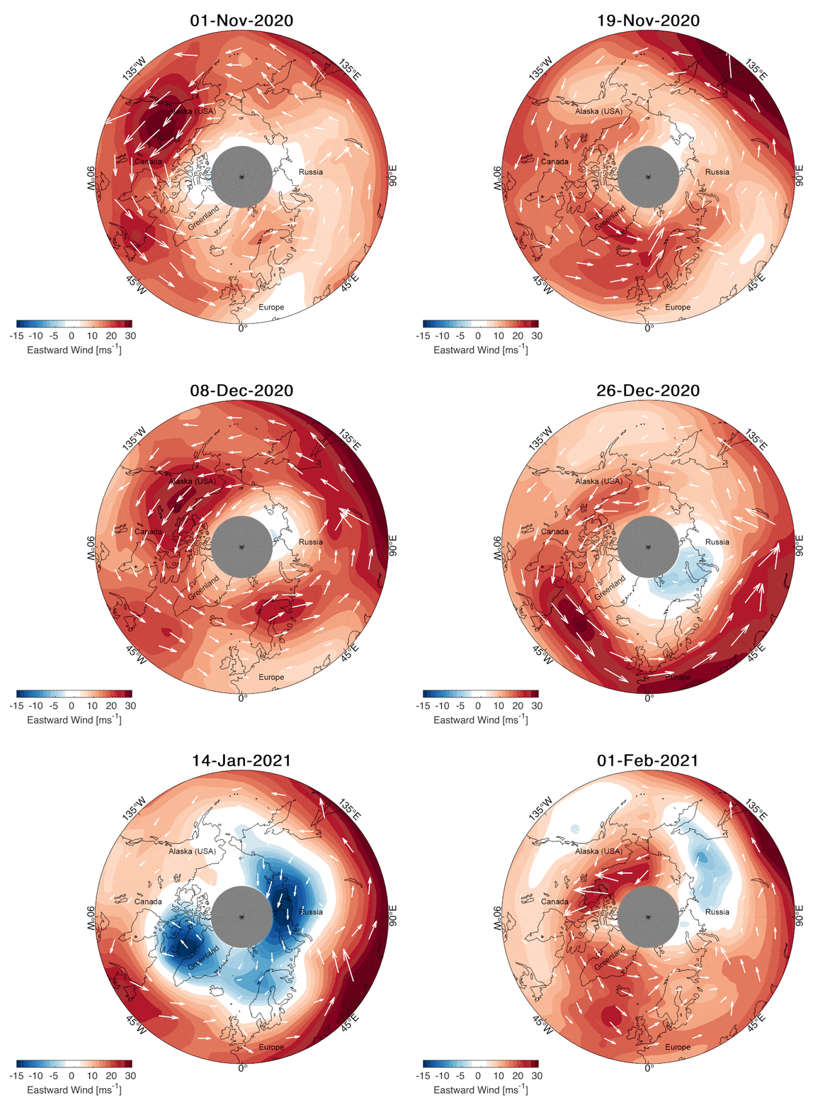
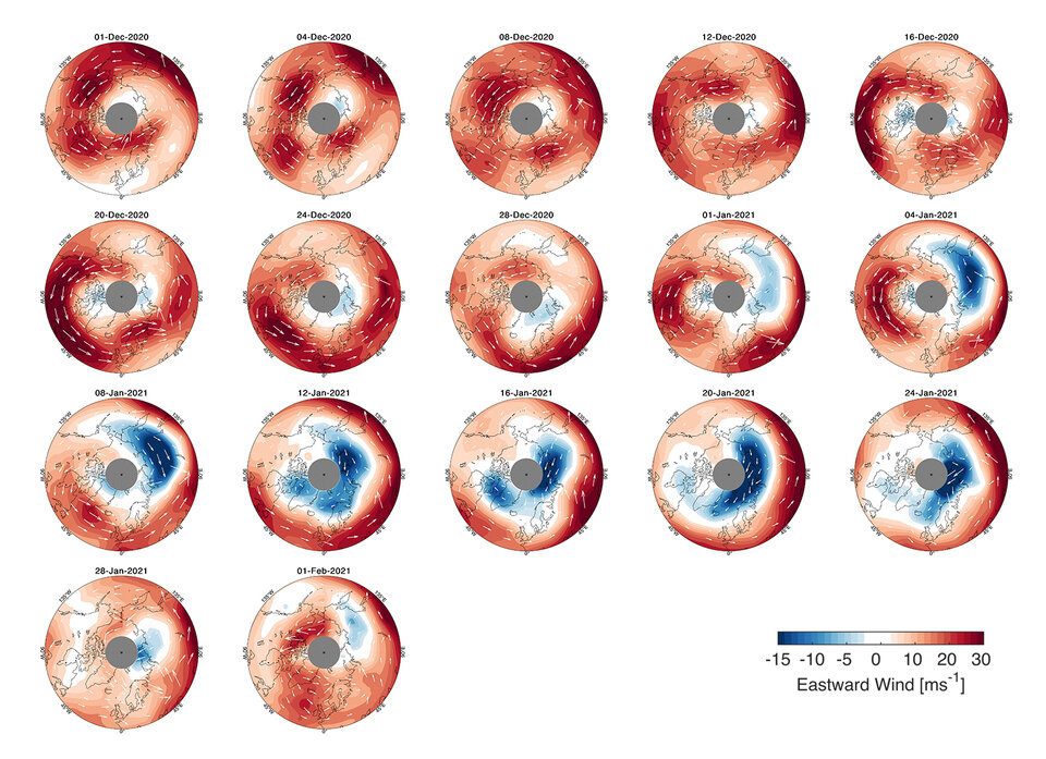
Polar vortex 1 December 2020 to 1 February 2021 One meteorological event that can disturb the polar vortex is known as a ‘sudden stratospheric warming’, which is what has been happening over the last month. Sudden stratospheric warmings happen to some extent every other year or so, but the current event has been categorised as major, and is less common.
Such dramatic events cause the strong wind around the edge of the polar vortex to weaken or reverse, leading the temperature of the polar stratosphere to rise rapidly by up to 50°C degrees Celsius over several days.
Since these events can trigger extreme weather in Europe and North America, they are of scientific and practical interest. However, the processes involved are not fully understood, and until recently there have been major technical challenges in measuring wind from space, which is needed to measure and monitor such a large-scale event.


Polar vortex change Fortunately, scientists now have ESA’s Aeolus satellite at hand to help understand more about why and how the polar vortex is pushed off balance.
Aeolus is the first satellite in orbit to profile directly Earth’s winds from space.
It works by emitting short, powerful pulses of ultraviolet light from a laser and measures the Doppler shift from the very small amount of light that is scattered back to the instrument from molecules and particles to deliver profiles of the horizontal speed of the world’s winds mostly in the east-west direction in the lowermost 26 km of the atmosphere.
Although Aeolus only measures wind in the lower part of the atmosphere, the lower part of the current stratospheric polar vortex jet leaves a signature in the satellite’s data.
Corwin Wright, Royal Society research fellow at the University of Bath in the UK, said, “Changes in the wind structure in a sudden stratospheric warming event have never been observed directly at a global scale before. So far, our understanding of these changes has been developed using point measurements, measurements along localised aircraft flight tracks, through the use of temperature observations, and, primarily, computer models and assimilative analyses.

Profiling the world's winds “However, we can now exploit novel measurements from Aeolus, the first satellite capable of observing winds directly in the upper troposphere and lower stratosphere, to study this process observationally during this current major event.”
Anne Grete Straume, ESA’s Aeolus mission scientist, commented, “We are currently observing a polar vortex event where we see it split into two, with one spinning mass of air over the North Atlantic and one over the North Pacific.
“The split leads to changes in the tropospheric circulation allowing cold air masses from the poles to more easily escape down to lower latitudes. At the moment, parts of North America seem to be experiencing colder weather than Europe, although we have seen events of cold air reaching quite far south in Europe over the past few weeks causing, for example, heavy snowfall in Spain.


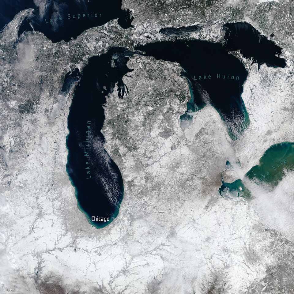
Snow near Great Lakes “What scientists would also like to understand is whether sudden stratospheric warming events might become more frequent owing to climate change. Also for this, Aeolus wind data will be very important to better understand the mechanisms triggering these weather events.
“It is early days yet to draw any scientific conclusions from our Aeolus data, but work is certainly underway to shed new light on why this seasonal phenomenon can sometimes be extreme – watch this space.”


https://www.esa.int/Applications/Observing_the_Earth/Aeolus/Aeolus_shines_a_light_on_polar_vortex
:ying:
 

trichrider

Kiss My Ring
Veteran
Glacial episodes of a freshwater Arctic Ocean covered by a thick ice shelf
Nature volume 590, pages97–102(2021)Cite this article

Abstract

Following early hypotheses about the possible existence of Arctic ice shelves in the past1,2,3, the observation of specific erosional features as deep as 1,000 metres below the current sea level confirmed the presence of a thick layer of ice on the Lomonosov Ridge in the central Arctic Ocean and elsewhere4,5,6. Recent modelling studies have addressed how an ice shelf may have built up in glacial periods, covering most of the Arctic Ocean7,8. So far, however, there is no irrefutable marine-sediment characterization of such an extensive ice shelf in the Arctic, raising doubt about the impact of glacial conditions on the Arctic Ocean. Here we provide evidence for at least two episodes during which the Arctic Ocean and the adjacent Nordic seas were not only covered by an extensive ice shelf, but also filled entirely with fresh water, causing a widespread absence of thorium-230 in marine sediments. We propose that these Arctic freshwater intervals occurred 70,000–62,000 years before present and approximately 150,000–131,000 years before present, corresponding to portions of marine isotope stages 4 and 6. Alternative interpretations of the first occurrence of the calcareous nannofossil Emiliania huxleyi in Arctic sedimentary records would suggest younger ages for the older interval. Our approach explains the unexpected minima in Arctic thorium-230 records9 that have led to divergent interpretations of sedimentation rates10,11 and hampered their use for dating purposes. About nine million cubic kilometres of fresh water is required to explain our isotopic interpretation, a calculation that we support with estimates of hydrological fluxes and altered boundary conditions. A freshwater mass of this size—stored in oceans, rather than land—suggests that a revision of sea-level reconstructions based on freshwater-sensitive stable oxygen isotopes may be required, and that large masses of fresh water could be delivered to the north Atlantic Ocean on very short timescales.


https://www.nature.com/articles/s41586-021-03186-y
////////

Melting icebergs key to sequence of an ice age, scientists find

13 January 2021
antarctic-icebergs.jpg
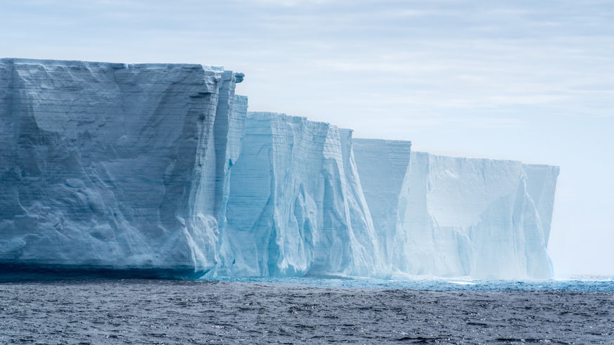
Scientists claim to have found the ‘missing link’ in the process that leads to an ice age on Earth.
Melting icebergs in the Antarctic are the key, say the team from Cardiff University, triggering a series of chain reactions that plunges Earth into a prolonged period of cold temperatures.
The findings have been published today in Nature from an international consortium of scientists from universities around the world.
It has long been known that ice age cycles are paced by periodic changes to Earth’s orbit of the sun, which subsequently changes the amount of solar radiation that reaches the Earth’s surface.
However, up until now it has been a mystery as to how small variations in solar energy can trigger such dramatic shifts in the climate on Earth.
In their study, the team propose that when the orbit of Earth around the sun is just right, Antarctic icebergs begin to melt further and further away from Antarctica, shifting huge volumes of freshwater away from the Southern Ocean and into the Atlantic Ocean.
As the Southern Ocean gets saltier and the North Atlantic gets fresher, large-scale ocean circulation patterns begin to dramatically change, pulling CO2 out of the atmosphere and reducing the so-called greenhouse effect.
This in turn pushes the Earth into ice age conditions.
As part of their study the scientists used multiple techniques to reconstruct past climate conditions, which included identifying tiny fragments of Antarctic rock dropped in the open ocean by melting icebergs.
The rock fragments were obtained from sediments recovered by the International Ocean Discovery Program (IODP) Expedition 361, representing over 1.6 million years of history and one of the longest detailed archives of Antarctic icebergs.
The study found that these deposits, known as Ice-Rafted Debris, appeared to consistently lead to changes in deep ocean circulation, reconstructed from the chemistry of tiny deep-sea fossils called foraminifera.
The team also used new climate model simulations to test their hypothesis, finding that huge volumes of freshwater could be moved by the icebergs.
Lead author of the study Aidan Starr, from Cardiff University’s School of Earth and Environmental Sciences, said: “We were astonished to find that this lead-lag relationship was present during the onset of every ice age for the last 1.6 million years."
Such a leading role for the Southern Ocean and Antarctica in global climate has been speculated but seeing it so clearly in geological evidence was very exciting.
Aidan Starr
Professor Ian Hall, co-author of the study and co-chief scientist of the IODP Expedition, also from the School of Earth and Environmental Sciences, said: “Our results provide the missing link into how Antarctica and the Southern Ocean responded to the natural rhythms of the climate system associated with our orbit around the sun.”
Over the past 3 million years the Earth has regularly plunged into ice age conditions, but at present is currently situated within an interglacial period where temperatures are warmer.
However, due to the increased global temperatures resulting from anthropogenic CO2 emissions, the researchers suggest the natural rhythm of ice age cycles may be disrupted as the Southern Ocean will likely become too warm for Antarctic icebergs to travel far enough to trigger the changes in ocean circulation required for an ice age to develop.
Professor Hall believes that the results can be used to understand how our climate may respond to anthropogenic climate change in the future.
“Likewise as we observe an increase in the mass loss from the Antarctic continent and iceberg activity in the Southern Ocean, resulting from warming associated with current human greenhouse-gas emissions, our study emphasises the importance of understanding iceberg trajectories and melt patterns in developing the most robust predictions of their future impact on ocean circulation and climate,” he said.
The Cardiff University-led study was funded by NERC.

https://www.cardiff.ac.uk/news/view...ey-to-sequence-of-an-ice-age,-scientists-find
/////////////
Researchers Link Ice-Age Climate-Change Records to Ocean Salinity


Water is saltier during cold, fresher with tropical rain
ice_f.jpg


October 4, 2006
Sudden decreases in temperature over Greenland and tropical rainfall patterns during the last Ice Age have been linked for the first time to rapid changes in the salinity of the north Atlantic Ocean, according to research published Oct. 5, 2006, in the journal Nature. The results provide further evidence that ocean circulation and chemistry respond to changes in climate.
Using chemical traces in fossil shells of microscopic planktonic life forms, called formanifera, in deep-sea sediment cores, scientists reconstructed a 45,000- to 60,000-year-old record of ocean temperature and salinity. They compared their results to the record of abrupt climate change recorded in ice cores from Greenland. They found the Atlantic got saltier during cold periods, and fresher during warm intervals.
"The freshening likely reflects shifts in rainfall patterns, mostly in the tropics," Howard Spero of the University of California at Davis said. "Suddenly, we're looking at a record that links moisture balance in the tropics to climate change. And the most striking thing is that a measurable transition is happening over decades."
Spero, who is currently on leave at the National Science Foundation's Marine Geology and Geophysics Program, worked with lead author Matthew Schmidt of the Georgia Institute of Technology and Maryline Vautravers of Cambridge University in the United Kingdom to conduct the research.
During the Ice Age, much of North America and Europe was covered by a sheet of ice. But the ice records the scientists reconstructed show repeated patterns of sudden warming, called Dansgaard-Oeschger Cycles, when temperatures in Greenland rose by 5 to 10 degrees Celsius over a few decades.
Close to the tropics, warm, moist air forms a zone of heavy tropical rainfall, called the Intertropical Convergence Zone, which dilutes the salty ocean with fresh water. Today, the tropical rainfall zone reaches into the northern Caribbean, but during the colder periods of the Ice Age it was pushed much further south, towards Brazil. That kept fresh water out of the northern Atlantic, so it became more salty, Spero said.
The circulation, or gyre, in the North Atlantic moves warm, salty water north, keeping Europe relatively temperate. The deep ocean circulation is very sensitive to the saltiness of north Atlantic surface waters, Spero said. Warming climate, higher rainfall and fresher conditions can alter the circulation. During glacial times, reduced circulation caused climate to cool.
The new results show that as the climate cooled in Greenland, salinity rapidly increased in the North Atlantic subtropical gyre. The build-up of salt during these cold intervals when the conveyor circulation was reduced would have primed the system to quickly restart on transitions into warm intervals, Schmidt said. However, the actual trigger that caused Atlantic circulation to restart during the Ice Age is still unknown, he said.
Once warming began, melting ice sheets would have contributed fresh water to the Atlantic, but this would have been partly buffered by the elevated saltiness of the Atlantic.
The research was supported by the National Science Foundation.

https://www.nsf.gov/news/news_summ.jsp?cntn_id=108053
//////////

US Deploys B-1 Bombers To Norway For First Time Amid Russia's Arctic Ambitions

by Tyler Durden

Thursday, Feb 04, 2021 - 4:15
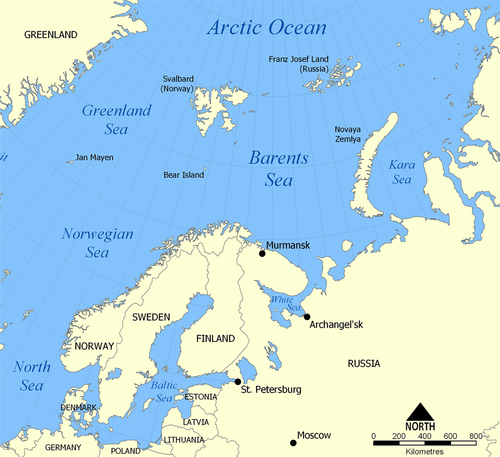
In recent years there's been a noticeable uptick in large-scale NATO exercises in the Barents region in response to what's perceived as Russia's own arctic ambitions to militarize the far north.
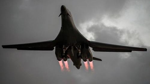
And now the US Air Force has announced that for the first time ever it will deploy B-1 Lancer bombers along with 200 airmen to Norway, no doubt in order to "confront Russia".
"More than 200 Air Force personnel from Dyess Air Force Base, Texas, were expected to arrive at Orland Air Base with an expeditionary B-1 Lancer bomber squadron to support missions in the region, U.S. European Command said in a statement Tuesday," according to Stars and Stripes.

lancerbomber.jpeg
B-1 Lancer, US Air Force imageUS European Command (EUCOM), which made the announcement this week didn't indicate how long they would be deployed, only saying "scheduled missions" will occur for "a limited time".
The US and Norwegian air forces have conducted long-range northern air patrols before, but this marks the first time American bombers will fly out of Norway, something sure to gain Russia's attention.
The move comes following the US Air Force and Navy recently publishing new Arctic defense strategies, in July and January respectively, also amid increased Pentagon cooperation with Norway, among the founding member countries of NATO.
The Navy's strategy, A Blue Arctic: A Strategic Blueprint for the Arctic is based on "an expected rise in the use of Arctic waters for commercial shipping, natural resource exploration, tourism and military presence" which calls for "the Navy and Marine Corps to increase regular presence in the Arctic."
barents.png

"Doing so will require the sea services to collaborate with allies as well as domestic partners like the Coast Guard and Alaska law enforcement organizations, and focus research and acquisition decisions on being able to operate successfully in the High North," according to the prior Navy statement.


https://www.zerohedge.com/geopoliti...rway-first-time-amid-russias-arctic-ambitions
 

1G12

Active member
The global race to produce hydrogen offshore

The global race to produce hydrogen offshore

Last year was a record breaker for the UK's wind power industry.

Wind power generation reached its highest ever level, at 17.2GW on 18 December, while wind power achieved its biggest share of UK energy production, at 60% on 26 August.

Yet occasionally the huge offshore wind farms pump out far more electricity than the country needs - such as during the first Covid-19 lockdown last spring when demand for electricity sagged.

But what if you could use that excess power for something else?

"What we're aiming to do is generate hydrogen directly from offshore wind," says Stephen Matthews, managing partner of manufacturing consultancy ERM.

His firm's project, Dolphyn, aims to fit floating wind turbines with desalination equipment to remove salt from seawater, and electrolysers to split the resulting freshwater into oxygen and the sought-after hydrogen.

TO READ THE FULL ARTICLE:

https://finance.yahoo.com/news/global-race-produce-hydrogen-offshore-001308563.html
 

igrowone

Well-known member
Veteran

armedoldhippy

Well-known member
Veteran
https://www.star-telegram.com/news/local/fort-worth/article249193010.html

Big highway pile-up with lots of deaths, related to unexpected ice on Texas freeway.

Is ice in Texas REALLY that unusual ? It sure caught hundreds of people by surprise on Thursday Feb. 11.

it went from rain to freezing rain to black ice within minutes. yeah, it WILL catch you by surprise like that. one minute wet, next thing you know "oh FUCKKKKK!" Mother Nature does shit like that, old bitch.
 

Sunshineinabag

Active member
[URL=https://www.esa.int/var/esa/storage/images/esa_multimedia/images/2021/02/polar_vortex_change/23130111-3-eng-GB/Polar_vortex_change_pillars.gif]View Image [/URL] Applications Aeolus shines a light on polar vortex

04/02/2021 2719 views 79 likes
ESA / Applications / Observing the Earth / Aeolus
As this winter’s polar vortex currently sends extreme icy blasts of Arctic weather to some parts of the northern hemisphere such as the northeast of the US, scientists are using wind information from ESA’s Aeolus satellite to shed more light on this complex phenomenon.

The polar vortex is a huge mass of frigid air high above the North Pole in the polar stratosphere. It is surrounded by a strong jet of air swirling counter-clockwise along the vortex’s boundary. The vortex tends to be much stronger in the winter, keeping bitter cold air locked in around the Arctic.
However, sometimes the vortex can weaken, become distorted or even split into two and meander further south, affecting the weather and jetstream further down in the troposphere, potentially bringing unusually cold weather and snow to lower latitudes.

[URL=https://www.esa.int/var/esa/storage/images/esa_multimedia/images/2021/01/polar_vortex_1_december_2020_to_1_february_2021/23130067-1-eng-GB/Polar_vortex_1_December_2020_to_1_February_2021_article.jpg]View Image [/URL] Polar vortex 1 December 2020 to 1 February 2021 One meteorological event that can disturb the polar vortex is known as a ‘sudden stratospheric warming’, which is what has been happening over the last month. Sudden stratospheric warmings happen to some extent every other year or so, but the current event has been categorised as major, and is less common.
Such dramatic events cause the strong wind around the edge of the polar vortex to weaken or reverse, leading the temperature of the polar stratosphere to rise rapidly by up to 50°C degrees Celsius over several days.
Since these events can trigger extreme weather in Europe and North America, they are of scientific and practical interest. However, the processes involved are not fully understood, and until recently there have been major technical challenges in measuring wind from space, which is needed to measure and monitor such a large-scale event.

[URL=https://www.esa.int/var/esa/storage/images/esa_multimedia/images/2021/02/polar_vortex_change/23130111-3-eng-GB/Polar_vortex_change_article.gif]View Image [/URL]
Polar vortex change Fortunately, scientists now have ESA’s Aeolus satellite at hand to help understand more about why and how the polar vortex is pushed off balance.
Aeolus is the first satellite in orbit to profile directly Earth’s winds from space.
It works by emitting short, powerful pulses of ultraviolet light from a laser and measures the Doppler shift from the very small amount of light that is scattered back to the instrument from molecules and particles to deliver profiles of the horizontal speed of the world’s winds mostly in the east-west direction in the lowermost 26 km of the atmosphere.
Although Aeolus only measures wind in the lower part of the atmosphere, the lower part of the current stratospheric polar vortex jet leaves a signature in the satellite’s data.
Corwin Wright, Royal Society research fellow at the University of Bath in the UK, said, “Changes in the wind structure in a sudden stratospheric warming event have never been observed directly at a global scale before. So far, our understanding of these changes has been developed using point measurements, measurements along localised aircraft flight tracks, through the use of temperature observations, and, primarily, computer models and assimilative analyses.

Profiling the world's winds “However, we can now exploit novel measurements from Aeolus, the first satellite capable of observing winds directly in the upper troposphere and lower stratosphere, to study this process observationally during this current major event.”
Anne Grete Straume, ESA’s Aeolus mission scientist, commented, “We are currently observing a polar vortex event where we see it split into two, with one spinning mass of air over the North Atlantic and one over the North Pacific.
“The split leads to changes in the tropospheric circulation allowing cold air masses from the poles to more easily escape down to lower latitudes. At the moment, parts of North America seem to be experiencing colder weather than Europe, although we have seen events of cold air reaching quite far south in Europe over the past few weeks causing, for example, heavy snowfall in Spain.

[URL=https://www.esa.int/var/esa/storage/images/esa_multimedia/images/2021/01/snow_near_great_lakes/23130155-1-eng-GB/Snow_near_Great_Lakes_article.jpg]View Image [/URL]
Snow near Great Lakes “What scientists would also like to understand is whether sudden stratospheric warming events might become more frequent owing to climate change. Also for this, Aeolus wind data will be very important to better understand the mechanisms triggering these weather events.
“It is early days yet to draw any scientific conclusions from our Aeolus data, but work is certainly underway to shed new light on why this seasonal phenomenon can sometimes be extreme – watch this space.”


https://www.esa.int/Applications/Observing_the_Earth/Aeolus/Aeolus_shines_a_light_on_polar_vortex
:ying:

Yep I remember quite vividly three yrs ago a winter where we went -10 or colder for almost two weeks ....the vortex is no joke
 
Top