What's new
  • ICMag and The Vault are running a NEW contest! You can check it here. Prizes are seeds & forum premium access. Come join in!

Geography, History and Human Universal Culture:

Montuno

...como el Son...
history and geography blog

turuñuelo e1554635080303

El Turuñuelo: the splendor and fall of Tartessos :​


The experts are shocked that the building is built with techniques and materials that were thought not to have been used throughout the Western Mediterranean until much later.

The steps are fixed with a kind of lime mortar and crushed granite (the Roman opus caementicium ), a century before the first material of these characteristics appeared.

Barely 10% of its surface has been excavated


For
Javier Ramos
15 February, 2019


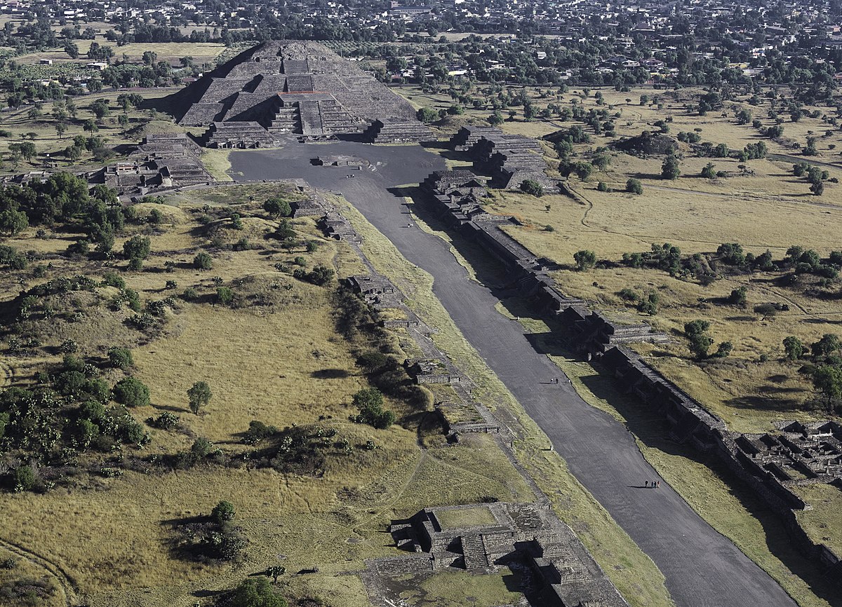
Built on the right bank of the Guadiana River, it is barely separated by seven kilometers from the Tartessian necropolis of Medellín with which, however, it does not have visual contact as the Yelbes mountain range intervenes. It is the tumulus of the Casas del Turuñuelo (in the municipality of Guareña, Badajoz), of great dimensions, which reaches two hectares in size. It is located in a flat valley landscape completely surrounded by irrigated land and is in a good state of conservation. It is about 2,500 years old.

According to Sebastián Celestino, a researcher at the Higher Council for Scientific Research (CSIC) who works in the area, Turuñuelo was populated at the end of the Tartessian era, in the 5th century BC. The central core was in the Guadalquivir and Huelva, but after an economic crisis in the 6th century BC there was a large population movement inland. And those people who settled in the Guadiana area built huge buildings like this one and the one in Cancho Roano .

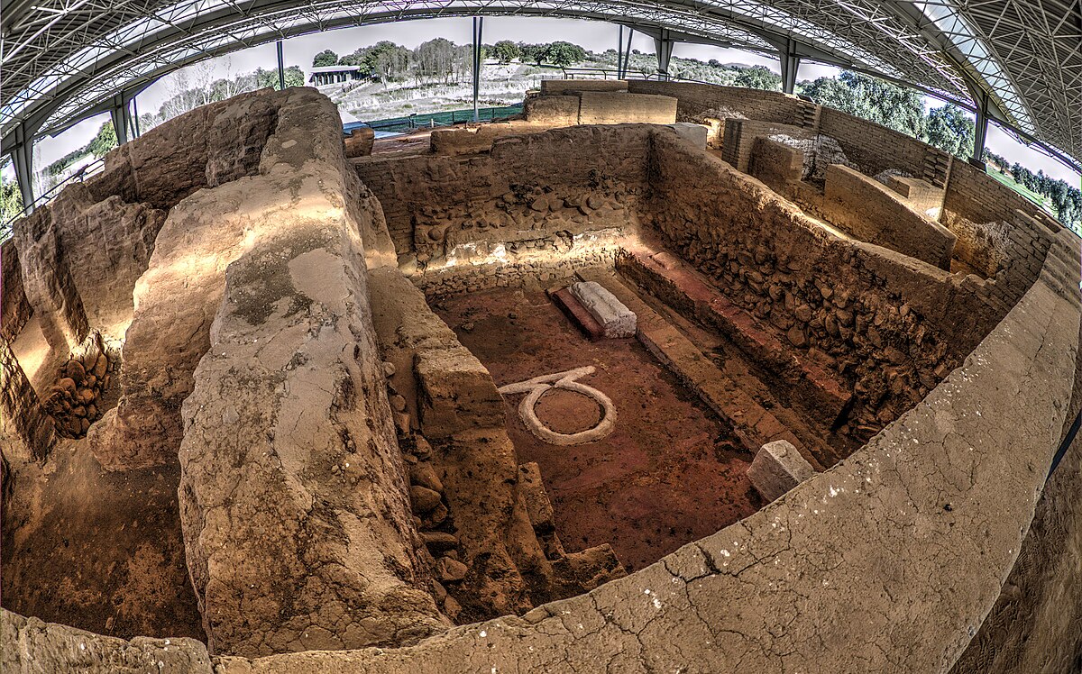
The dimensions of the remains found at the Turuñuelo site are striking: the walls reach up to three meters in height at some points and the whitewash and slate that covered and decorated them are almost intact.

a monumental building​

For the moment, one of the 70-square-meter rooms has been completely excavated, which has revealed significant elements, such as a large continuous bench attached to the north wall, as well as an altar in the shape of an extended bull's skin or the presence of a grill and a bronze cauldron, which suggest its connection with cultural activities.

To these finds are added the ivory plates of a wooden box decorated with two lions, boats and fish; an outstanding volume of iron from the door fittings; a large number of bronzes belonging to jars, braziers and grills or two braided esparto mats. The room was accessed through a monumental door with a span of 1.70 meters made up of three steps and flanked by two quadrangular pillars that still retain part of their decoration.

moat_turuñuelo
Animals sacrificed in a ritual celebrated 2,500 years ago in a building found in Guareña./ Carlos Carcas

But what has most attracted the attention of archaeologists has been the recent discovery of a stairway with ten steps, two meters long by 40 centimeters wide and about 20 centimeters thick, made of granite and covered with slate, carefully joined with something similar to cement. The find is three times larger than the Cancho Roano site and what is surprising is its impressive state of preservation. It points to an unusual two-story building.

surprise architecture​


The experts are shocked that the building is built with techniques and materials that were thought not to have been used throughout the western Mediterranean until much later.

The steps are fixed with a kind of lime mortar and crushed granite (the Roman opus caementicium ), a century before the first material of these characteristics appeared.

The building has characteristics of a palace, but also of a great funerary monument.


One of the latest novelties that the excavation has brought about are the bones found of an adult person, probably a man around 1.67 meters tall, which will provide DNA for further investigation. These remains have been discovered in a room other than the patio in which more than fifty horses and other sacrificed animals have appeared, the researchers believe, it is a kind of ritual.

boarded up and set on fire​

Most of the constructions of that time in the Guadiana valley were destroyed by their own inhabitants towards the end of the 5th century, or the beginning of the 4th, due to the harassing harassment of the Celtiberian tribes from the north of the peninsula. Turuñuelo was no exception. It was set on fire and then buried under clay taken from the Guadiana River, which has served as a protective framework. Hence its excellent state of preservation.

El Turuñuelo is one of the best preserved sites of the Tartessian culture.

Barely 10% of its surface has been excavated, so it is certain that in the future it will bring us new and revealing discoveries that may perhaps change the course of history that we know today.

deposit_turuñuelo
Only 10% of the site in Badajoz has been excavated.


This spectacular archaeological landmark of our country occupies an important space in the book El Enigma Tartessos
51YSBYgOgfL._AC_SY1000_.jpg

Enigma Tartessos, by Javier Ramos and Javier Martínez Pinna (Editorial Actas) A journey into the past through the mysteries that surround the Tartessian culture and the places that formed part of its territory.


Guareña and its past​

Back in the present, the traveler who has fallen in love with this archaeological complex has the opportunity to go to the neighboring town of Guareña to discover the heritage charms that it preserves and makes available to them. This is the homeland of the poet and playwright Luis Chamizo Trigueros, who used the language of his native town in his popular poetry and which has become one of the attributes most recognized by his countrymen.

Guareña is one of the best examples of Baja Extremadura. His rich past is easily guessed when the traveler contemplates the magnificent mansions of rich farmers that still remain. The Town Hall stands out , with a classicist design and built entirely in granite masonry in the 18th century. Monumental is also its Renaissance church in which Juan de Herrera himself, the architect of El Escorial , worked .

Where to sleep: Hostal Restaurante Kavanna; 06893 San Pedro de Mérida, (Badajoz); Telephone: 924325022.
-Hostal Fuente de la Magdalena; Spain Square, 20; 06410 Santa Amalia (Badajoz); phone: 605492652.

Where to eat: El Coto; Ctra. Don Benito, S/N; 06470 Guarena, Badajoz; telephone: 924351441.
-Millennium; San Gines Street, 19; 06470 Guarena, Badajoz; phone:924351613.
 
Last edited:

Montuno

...como el Son...
And speaking of the Maya . . . probably Veracruz culture

View attachment 18123947

Screenshot_2022_0420_025432.png

Screenshot_2022_0420_023421.png


Teotihuacan /teɪˌoʊtiːwəˈkɑːn/[1] (Spanish: Teotihuacán) (Spanish pronunciation: [teotiwa'kan] ( listen); modern Nahuatl pronunciation (help·info)) is an ancient Mesoamerican city located in a sub-valley of the Valley of Mexico, which is located in the State of Mexico, 40 kilometers (25 mi) northeast of modern-day Mexico City. Teotihuacan is known today as the site of many of the most architecturally significant Mesoamerican pyramids built in the pre-Columbian Americas. At its zenith, perhaps in the first half of the first millennium (1 AD to 500 AD), Teotihuacan was the largest city in the pre-Columbian Americas, with a population estimated at 125,000 or more,[2][3] making it at least the sixth-largest city in the world during its epoch.[4]

Teotihuacan
History
Site notes
Architecture
UNESCO World Heritage Site
Teotihuacán-5973.JPG
View of the Avenue of the Dead and the Pyramid of the Moon.
Teotihuacan is located in Mesoamerica
Teotihuacan

Location of the site
Show map of MesoamericaShow map of MexicoShow map of State of MexicoShow all
LocationTeotihuacán, State of Mexico, Mexico
Coordinates19°41′33″N 98°50′38″W
PeriodsLate Preclassic to Late Classic
Architectural stylesTalud-tablero
Official namePre-Hispanic City of Teotihuacan
CriteriaCultural: i, ii, iii, iv, vi
Reference414
Inscription1987 (11th Session)
Area3,381.71 ha
The city covered eight square miles (21 km2); 80 to 90 percent of the total population of the valley resided in Teotihuacan. Apart from the pyramids, Teotihuacan is also anthropologically significant for its complex, multi-family residential compounds, the Avenue of the Dead, and its vibrant, well-preserved murals. Additionally, Teotihuacan exported fine obsidian tools that are found throughout Mesoamerica. The city is thought to have been established around 100 BC, with major monuments continuously under construction until about 250 AD.[2] The city may have lasted until sometime between the 7th and 8th centuries AD, but its major monuments were sacked and systematically burned around 550 AD. Its collapse might be related to the extreme weather events of 535–536.

Teotihuacan began as a religious center in the Mexican Highlands around the first century AD. It became the largest and most populated center in the pre-Columbian Americas. Teotihuacan was home to multi-floor apartment compounds built to accommodate the large population.[2] The term Teotihuacan (or Teotihuacano) is also used for the whole civilization and cultural complex associated with the site.

Although it is a subject of debate whether Teotihuacan was the center of a state empire, its influence throughout Mesoamerica is well documented; evidence of Teotihuacano presence is present at numerous sites in Veracruz and the Maya region. The later Aztecs saw these magnificent ruins and claimed a common ancestry with the Teotihuacanos, modifying and adopting aspects of their culture. The ethnicity of the inhabitants of Teotihuacan is the subject of debate. Possible candidates are the Nahua, Otomi, or Totonac ethnic groups. Other scholars have suggested that Teotihuacan was multi-ethnic, due to the discovery of cultural aspects connected to the Maya as well as Oto-Pamean people. It is clear that many different cultural groups lived in Teotihuacan during the height of its power, with migrants coming from all over, but especially from Oaxaca and the Gulf Coast.[5][6]

After the collapse of Teotihuacan, central Mexico was dominated by more regional powers, notably Xochicalco and Tula.

The city and the archeological site are located in what is now the San Juan Teotihuacán municipality in the State of México, approximately 40 kilometers (25 mi) northeast of Mexico City. The site covers a total surface area of 83 square kilometers (32 sq mi) and was designated a UNESCO World Heritage Site in 1987.[7] It is the most visited archeological site in Mexico, receiving 4,185,017 visitors in 2017.[8]
MORE:

MORE:
 
Last edited:

Montuno

...como el Son...

Teotihuacán

Teotihuacán - information & photo tour

Photo tour | Location

teotihuacan.jpg


Teotihuacán is one of the world's most impressive archaeological sites. The pyramid city, inhabited between 100 B.C. and 650 A.D., is located in a wide valley in Central Mexico on a height of aprox. 2,300 m, hence almost on the same level as the Mexican capital, which is only 50 km far. Even though Teotihuacán has been explored scientifically since more than a century, 95% of the ruins haven't been excavated yet.
Until its mysterious end in the 7th century, which was accompanied by a devastating fire, Teotihuacán was a powerful political, military, economic and cultural centre that influenced the whole of Mesoamerica. In its heyday, more than 150,000 inhabitants lived thereon an area of 20 square kilometres, so that the city was one of the largest metropolis of the world in that era.
It is still not known, who were the inhabitants of Teotihuacán, and not even its original name is known. When the Aztecs arrived on the Mexican Central Plateau in the first half of the 14th century, coming from the North, and discovered the abandoned ruins of the city, they connected it with their own creation myth, and gave it the name of Teotihuacán – "place where gods were born". Also, the denominations of the Pyramids of the Sun and Moon as well as the "Avenue of the Dead", can be traced back to the Aztecs.

The City​

At the beginning of the 2nd century A.D. an overall concept for the urban planning of Teotihuacán was realised. With its unique chessboard layout the city was the unequivocal manifestation of a centralized rule. The main axis running from north to south, with a deviation to the East of 15.5 degrees, is the "Avenue of the Dead", which begins at the Pyramid of the Moon and leads past the Pyramid of the Sun.
Teotihuacán was laid out along wide avenues and had efficiently functioning drainage and water-supply systems. The pyramids, temples and palaces were coated with stucco and decorated with murals in brilliant colours. There were public buildings, administrative quarters, and various residential areas. Teotihuacán was a cosmopolitan city that accommodated a considerable number of outsiders. People from the Maya, Oaxaca and Gulf Coast areas lived in separate districts of the city. Although they were living far from their homelands, they often retained many elements of the own culture.
The main pyramids are the 63-metre-high Pyramid of the Sun, with a lateral length of 225 metres, and the 48-metre-high Pyramid of the Moon at the northern end of the two kilometre-long Avenue of the Dead. The southern end of the ensemble, of which only a fraction has been excavated and studied, is dominated by what the Spaniards called the "Citadel", containing the Temple of Quetzalcoatl, the Feathered Serpent, and the Rain God, Tlaloc, which is decorated with 365 sculptured heads of these divinities.

Main divinities​

The names of the gods that were worshipped in Teotihuacán are not known. There is definite agreement, however, about their iconography. The same deities can be found again with the Aztecs. The gods of Teotihuacán can therefore be equated with the Aztec gods and are called by the same names: Tlaloc was the Storm God, the god of rain and fertility. But he also embodies the destructive power of rain and water in the form of thunderstorms and floods. Quetzalcoatl is the rattlesnake with the feathers of the quetzal bird. The Feathered Serpent was responsible for the fertility of the earth and for life itself. Tlaloc and Quetzalcoatl are among the most important deities in Teotihuacán. Huehueteotl, the Old God, who was responsible for fire and was worshipped primarily in the private sphere. He was the patron saint of house and hearth. Huehueteotl is represented sitting cross-legged, with a wrinkled face and a brazier or coal pan on his head.

System of Rule​

Little is known about the form of government that existed in Teotihuacán. It can be assumed, however, that at the beginning of the 2nd century at the latest – when the overall urban planning was realized in Teotihuacán – the fate of the city lay in the hands of an individual leader. The seat of government was most likely located at different places: in the monumental Xalla building compound located to the north of the Pyramid of the Sun and in the living quarters of the Citadel flanking the Pyramid of the Feathered Serpent. In the 4th century a radical change must have come about: the huge sculpted serpent’s heads of the Quetzalcoatl Pyramid were smashed and a large platform was erected on one side. After this act of destruction the subsequent rulers built their seat of government right above the "Avenue of the Dead".
Even today we still do not know any of the names of the Teotihuacán rulers, and we do not possess any inscriptions that would give testimony to their achievements. This contrasts sharply with the concomitant Maya civilization, the dynastic history of which is well-known: they erected steles with inscriptions that glorified their rule and recorded the important events of their lives on them.

Trade, War, Sphere of Influence​

The enormous wealth of Teotihuacán was based largely on the monopoly they had on the trade of obsidian, a coarse green glass occurring in volcanic rock. The most important deposit of obsidian in Mesoamerica is found near the city. Ceramics were also highly prized export goods, particularly the splendidly decorated, cylindrical tripod vessels. With the help of its extensive trading network and monopoly on long-distance trade, its political contacts, but also its military invasions, Teotihuacán was able to extend its sphere of influence beyond the Altiplano, the central highland, and deep into areas throughout Mesoamerica.
Teotihuacán’s influence is mirrored above all, however, in the art and architecture of Mesoamerica. The talud-tablero method of façade construction that had been developed in Teotihuacán – the alternating sequence of steeply sloping and frame-like projecting vertical walls – placed its mark on architecture in many places throughout Mexico. Of course it is not easy to determine where Teotihuacán people themselves settled or where their cultural singularities were merely imitated. In any case, archaeological indices support the theory that the Teotihuacanos asserted their influence in the Maya territories: in Kaminaljuyu they took power in the 4th century and in Tikal they even founded their own dynasty. There are also clear signs that they intervened in politics in other Maya areas as well. These expansionist tendencies were part of a larger phenomenon that was not limited to the Maya territory, but can also be found in Monte Albán, the capital city of the powerful Zapotec civilization. The Teotihuacanos carried on intensive relations with the Zapotecs, and there is even a possibility that they ruled over Monte Albán for a certain length of time.

The Downfall of Teotihuacán​

The city of Teotihuacán was the most complex and populated urban centre in the period between the 3rd and the 6th centuries – a cultural and economic "superpower". The dominant cultural position of Teotihuacanin Mesoamerica came to an end in the 7th century. Large areas of the metropolis were ravaged by fire. The reasons are still unclear; its destruction possibly came about as a result of an invasion or an internal rebellion. After this trauma part of the city remained inhabited for around a century. The city was then finally abandoned.

https://universes.art/en/art-destinations/mexico/tour/teotihuacan

teotihuacan.jpg
57aa487e70bcb7f060f9652a4b14de98.png
comercio-de-la-cultura-teotihuacana.jpg
teotihuacan_mapa_2.jpg
ubicacion teotihuacan.jpg
Figura-61-Mapa-donde-se-observa-las-areas-de-influencia-de-Teotihuacan-y-de-Monte-Alban.png
 
Last edited:

Montuno

...como el Son...

Cancho Roano:​

archaeological site in Zalamea de la Serena, Spain

Cancho Roano (sometimes written as Cancho Ruano ) is an archaeological site located in the municipality of Zalamea de la Serena , in the province of Badajoz ( Spain ). It is located three kilometers from Zalamea in the direction of Quintana de la Serena , in a small valley next to the Cagancha stream. [ 2 ]

Location map
General data
Location
Roan Cancho
Asset of Cultural Interest
Historical Heritage of Spain
AMF0500 tn.jpg
Country Spanish flag Spain
LocationZalamea de la Serena , ( Badajoz )
coordinates38°42′05″N 5°41′03″W / 38.701426 , -5.684165
CategoryArchaeological area
CodeRI-55-0000239 [ 1 ]
StatementFebruary 10, 1989
Cancho Roano is located in Badajoz Province
Roan Cancho

Roan Cancho

Location in Badajoz Province.
[ edit data at Wikidata ]


ContentEdit


Model of Cancho Roano
It is the best preserved Tartessian - Turdetan complex in the Iberian Peninsula , dating the original construction to at least the 6th century BC. C. , although the building was enlarged and modified in later centuries. It is undoubtedly an exceptional and unique site, both for its shape, size and state of conservation, as well as for the objects found, which allow its creation to be dated to around 550 BC. C. , while its destruction would not be later than 370 a. C. , caused by a fire, either accidental or intentional, within some type of religious rite.

Contradicting the exposed version, the attribution to Tartessos is limited only to a lower level of excavation, the so-called "D" level. To the time in which that civilization existed (9th to 7th centuries BC) only the remains of the bottom of the cabin correspond, which are found below the most voluminous now visible, level "A". Therefore, the building from the 5th to 4th centuries BC, which came to be called a "palacete" by Maluquer and collaborators, is actually a blood altar for ritual sacrifices, with a typology defined for similar ones in the eastern Mediterranean, as defined by Professor Antonio Blanco Freijeiro, and of course, much later than the Tartessian civilization. What corresponds to a time two centuries after the disappearance of Tartessos cannot be called a "Tartesian ensemble", nor can small rooms be called a "palace" in any way adapted to the sumptuary and political function that such a type is supposed to have. of constructions. Later investigations attribute a Phoenician architectural character to it , possibly built at the behest of a wealthy indigenous person. [ 3 ]

The evidently sacred character of the building and the presence of numerous rooms, similar to separate cells, has attracted the hypothesis that it could be a temple dedicated to the practice of sacred prostitution in honor of the fertility goddess Astarte . [ 4 ] [ 5 ] This thesis is supported by the presence of looms in two of the rooms, evoking the weavers of the goddess Ashera who practiced prostitution in the ancient temple of Jerusalem . [ 6 ] Similar rites would have been identified in the iconography of other Phoenician-Punic sites, such asGadir , Cástulo and la Quéjola ( Albacete ). [ 7 ] Another possibility would be a mansion destined to house a harem , although without ruling out the participation of its members in sexual fertility rites. [ 3 ] [ 6 ] [ 7 ]

The main body of the building, with a square floor plan, faces east, and is surrounded by a shallow moat , which permanently contains water; Apparently the idea of its builders was to maintain a sheet of water throughout the year. Although its exact function is unknown, its religious character is undeniable due to the altars it contains; although it could also be a palace-sanctuary, judging by its defensive device. Inside, abundant objects have been found, such as amphorae containing cereals, beans, nuts and possibly wine, stone mills, ceramic and metal vessels, ceramics from Attica dated between 430 and 375 BC. C., ornate furniture ofivory , silver rings and earrings, perfume containers, game pieces, cavalry accessories, iron weapons or high-quality bronze statuettes and sculptures, as well as the remains of one man and six women. [ 8 ]

The excavations, directed by Juan Maluquer de Motes , began in 1978 . Given its importance, the site was declared a national monument in 1986 . It can be visited in its entirety, with an interpretation center where the visitor has explanations through posters, a multimedia presentation and a model . This center belongs to the Network of Identity Museums of Extremadura
MORE:
 

Montuno

...como el Son...

Cancho Roano​

Cancho Roano (sometimes Cancho Ruano) is an archaeological site located in the municipality of Zalamea de la Serena, in the province of Badajoz, Spain. Is located three miles from Zalamea de la Serena in the direction of Quintana de la Serena Quintana, in a small valley along the stream Cagancha.


Model of Cancho Roano


HistoryEdit

Cancho Roano is the best preserved Tartessian site. It dates back to at least the sixth century BCE, although the building was expanded and modified in later centuries. Based on the dating of objects found on the site, Cancho Roano is estimated to date from 550 BCE. The site was destroyed in a fire no later than 370 BCE. The building appears to have been ritually burned and sealed in rammed earth in a manner similar to Etruscan. The main body of the building is square and oriented toward the east. The building is surrounded by a deep moat, which was permanently filled with water. Although Cancho Roano's exact function is unknown, the religious character of the site is undeniable due to the presence of altars; however, the site may be a palace-shrine, judging from its defensive system.


Discovery and excavationsEdit

Excavations of the site, directed by John Maluquer de Motes, began in 1978 and continued through 2001. It was declared a National Monument in 1986. The site, along with an interpretation center, is open to the public.


InterpretationsEdit

The evident sacred character of the building and the presence of multiple cells have attracted the idea of a temple dedicated to sacred prostitution, possibly dedicated to the Phoenician deity Astarte.[1][2] The hypothesis is supported by the presence of looms in two of the chambers, evoking the weavers of the goddess Asherah that worked as prostitutes in the ancient Temple of Jerusalem.[3] Similar rites would have been identified on the iconography of other Phoenician sites in Hispania, like Gadir, Castulo and La Quéjola (Albacete).[4] Another possibility would be a palace meant to accommodate a harem, whose members would likely act in sacred rites on the temple.[5][3][4]

Richard Freund theorizes that Cancho Roano was a "memorial city" designed to serve as a ceremonial representation of the lost city of Tartessos, which, in Freund's theory, was also Atlantis. Freund argued that a stele found at Cancho Roano displayed an image with concentric circles that matches Plato's description of Atlantis.[6] Nonetheless, Freund’s theories have been widely dismissed in academic circles, and the symbol is not much more than a typical warrior shield engraved in the Southwestern Stelae from the Iberian Peninsula, of which there are many examples.[7]

 
Last edited:

Montuno

...como el Son...

Cancho Roano (Photo gallery):​

archaeological site in Zalamea de la Serena, Spain

Icone chateau fort.svg
This is a category about an archaeological zone indexed in the Spanish heritage register of Bienes de Interés Cultural under the reference RI-55-0000239.
Cancho Roano

Media in category "Cancho Roano":​

The following 78 files are in this category, out of 78 total.


tobedetermined

Well-known member
Premium user
ICMag Donor
@Montuno Thank you for the research. The figure on the left looks very similar in style. I bought all of my small collection in the 90s during the early wild days of the Internet when anything and everything was for sale. Unfortunately, without provenance, antiquities just become pretty objects that you cannot auction, export or even sell without risking confiscation. And I am sure that even if I did go to the effort to try to return them to their respective countries of origin, they would end up unseen in a box on a museum shelf or as decoration adorning some official’s office. So I will just enjoy them and let my kids figure out what to do with them.

Gracias por la investigación. La figura de la izquierda tiene un estilo muy similar. Compré toda mi pequeña colección en los años 90 durante los primeros días salvajes de Internet cuando todo estaba a la venta. Desafortunadamente, sin procedencia, las antigüedades se convierten en objetos bonitos que no se pueden subastar, exportar o incluso vender sin correr el riesgo de ser confiscados. Y estoy seguro de que aunque hiciera el esfuerzo de tratar de devolverlos a sus respectivos países de origen, terminarían sin ser vistos en una caja en la estantería de un museo o como decoración que adorna la oficina de algún funcionario. Así que simplemente los disfrutaré y dejaré que mis hijos descubran qué hacer con ellos.
 

Montuno

...como el Son...

Cancho Roano (Zalamea de la Serena, Badajoz, Extremadura; Spain):​


.

.

.

.

.

descarga (11).jpeg


santuario-tartesico-de-cancho-roano-reconstruccion-ideal-de-este-edificio-de-gran-importancia-...jpg
el-santuario-tartesico-de-cancho-roano (1).jpg
85e19fc449d213ac38aff1e7ea9edcb8.jpg
santuario-tartesico-de-cancho-roano-reconstruccion-ideal-de-este-edificio-de-gran-importancia-...jpg
5-0.jpg
 
Last edited:

Montuno

...como el Son...
unnamed.png

Themes / Mayans
TEOTIHUACANOS AND MAYANS

Clash of Empires in Mesoamerica:​

New archaeological discoveries at the Mexican site of Teotihuacán reveal that perhaps the relationship between this culture (the Teotihuacan) and the Mayan world was prior to the date officially established so far, in 378 AD:​


Mayans Teotihuacan Present
Teotihuacán was a city that in that period had a population close to 100,000 people.

Photo: iStock

carme mayans

carme mayans
editor
updated to March 16, 2020 4:34 PM ·


recent discoveries at the Teotihuacán site, in the Valley of Mexico, seem to shed new information on the relations between two important Central American cultures, the Teotihuacans and the Maya, some 1,600 years ago. An article published in the journal Science summarizes the studies carried out by a team of archaeologists from Arizona State University and the University of California Riverside , who have been excavating in the Mexican city for a few years, on the findings and their meaning.

THE CONQUEST OF TIKAL​

On January 14 of the year 37.8 Sihyaj K'ahk' (The fire is born) arrived at Tikal. The arrival of this character, described by the epigrapher Davis Stuart as "The Entrance" is reflected in some Mayan stelae at the site, such as 31. Archaeologists believe that Sihyaj K'ahk' was a powerful warrior from Teotihuacán, the great metropolis of the Valley of Mexico –located about a thousand kilometers away from Tikal–, a city that at that time had a population of close to 100,000 people.

On January 14, 37.8 Sihyaj K'ahk' arrived at Tikal. Archaeologists believe that Sihyaj K'ahk' was a warrior from Teotihuacán.
But apparently, Sihyaj K'ahk' did not arrive only at Tikal, but accompanied by a powerful army. What the stelae do not record, however, is the reason for his arrival and how he was received by the then ruler of Rikal Chak Tok Ich'aak (Jaguar Claw). Interestingly, the same day that Sihyaj K'ahk' arrived in Tikal, Jaguar Claw passed away.

(to know more) :
Revolution in Mayan archaeology: thousands of hidden structures appear in the Guatemalan jungle

The Mayan civilization was much larger than previously believed!

read article


WHAT THE STELAE OF TIKAL SAY​

According to the engravings on some Mayan monuments, Sihyaj K'ahk' had been sent to Tikal by Átlatl Cauac (Spearthrower Owl), ruler of Teotihuacán. Be that as it may, two years after the arrival in Tikal of Sihyaj K'ahk', the son of Owl Thrower, named Yax Nuun Ayiin, became lord of the Mayan city. This character is depicted on the Mayan stelae of Tikal brandishing an atlatl , a throwing weapon characteristic of Teotihuacan warriors.He also wears a typical headdress of this culture. In addition to images of this sovereign, images of his father, Owl Thrower, have been found in Tikal, engraved in the flat style so characteristic of Teotihuacán, which has nothing to do with the intricate and naturalistic style of Mayan portraits. Apparently, from the reign of Yax Nuun Ayiin Tikal gained power among the rest of the Mayan cities.

Yax Nuun Ayiin, lord of Tikal, appears on the Mayan stelae of Tikal wielding an atlatl, a characteristic weapon of Teotihuacan warriors.
Although the theory of the Teotihuacan conquest of the Mayan world is not accepted by all researchers (some think that the events of the year 378 may have been an isolated case, or even that Sihyaj K'ahk' and his army were local Mayan usurpers who appropriated the symbolism of distant Teotihuacán), the new archaeological evidence discovered in Teotihuacán has reopened the debate about the true relationship between these two great Mesoamerican cultures, and seems to confirm that it was not very peaceful.

Temple of the Great Jaguar, Tikal, Guatemala

Photo: Guatemala Tourism

FINDINGS AT TEOTIHUACAN​

The Mayan stelae of Tikal suggest that Teotihuacán completely conquered this city as well as others in the Mayan area, and the archaeological finds made in the Plaza de las Columnas de Teotihuacán, carried out by North American archaeologists, seem to demonstrate two things: that in that period , for some unknown reason, Teotihuacán turned against the Mayan expatriates who had lived for decades in peace in their city and that the interaction between the two cultures may have been older than previously thought. In fact, the anthropologist Nawa Sugiyana, from the University of California Riverside, has highlighted four cases of archaeological contexts at the site that would suggest that the Mayan elites participated in public events in the Plaza de las Columnas de Teotihuacán before the year 378.

It is about more than two thousand remains of disarticulated human skeletons,
which were surely dismembered, many of them with traces of cuts. According to the anthropologist, at least three skulls had cranial deformations and some had dental mutilations. All this is very unusual in the Teotihuacán area, but very characteristic of the Mayan world. What appear to be the remains of a great celebration have also been located , with thousands of animal bones and ceramic remains, of which 68% were Teotihuacan style, but the rest had iconographic elements characteristic of the Mayan world. Likewise, some fragments of walls with Mayan-style mural painting were found that apparently were intentionally demolished,in a ritual way. Finally, a series of pieces were discovered, such as 95 obisdian objects, seashells, 50 pieces of green stone, as well as the remains of some sacrificed animals, including a golden eagle and the complete skeleton of a spider monkey, a species that it is not native to the area.

68% of the ceramic remains discovered in the Plaza de las Columnas de Teotihuán are of the Teotihuacan style.
After analyzing all these findings and performing radiocarbon dating, archaeologists provide a more accurate chronology on the relationship between Teotihuacán and Tikal (or the Mayan world in general). The dates considered would be between 300 and 350 AD (before the date traditionally accepted until now of 378 AD, when Tikal was presumably conquered), and between 350 and 450 AD.

The researchers are convinced that all these discoveries, and many more likely to come in the future, will help shed more light on this history of political and cultural clashes between the Mayan world and the flourishing Teotihuacan civilization. What is clear is that this interaction, peaceful or not, helped spark the flourishing of Tikal and ended up turning it into one of the most prosperous and important Mayan cities around it.

(to know more) :
They detect a possible tunnel in Teotihuacán, Mexico

Detected an underworld tunnel in Teotihuacán

read article


Montuno

...como el Son...
13dd9f4757694f901a21b1a8204e22d6.png


WHAT THE STELAE 31 OF TIKAL SAY​


Stela 31 from Tikal, Guatemala

Stela 31 from Tikal, Guatemala

Stela 31 recorded the conquest of Tikal in 378 AD by the Teotihuacans. On the sides of him is a curved Nose dressed as a Teotihuacan warrior. You can also see the glyph of his father, the ruler of Teotihuacán: Dart Owl. According to Stela 31 found at Tikal, Átlatl Cauac ( Spearthrower Owl ) takes the throne of Teotihuacán.
The limestone stela is carved on all four sides, and on the sides appear the figures of a couple of individuals dressed in simple Teotihuacan clothing, in addition to carrying a shield and an "atlatl" or dart thrower. The represented ruler wears a large headdress and carries on his left arm the figure of the Jaguar God of the underworld. The scene is a historical record of the contact that the Mayans had with the Teotihuacan culture, who contributed various artistic elements, especially in the art of ceramics.

Credit http://mundodelmuseo.com/ficha.php?id=571. Location Sylvanus G. Morley Tikal Site Museum, Guatemala.


inah1-compressor.jpg

Teotihuacan lineage in Guatemala​

March 29, 2010

*** Studies in Teotihuacan murals confirm the extension of the lineage of a ruler of the ancient City of the Gods in Tikal, Guatemala

*** The image represented by an owl with a shield would be the emblem of the ruler of Teotihuacan, Atlatl-Cauac


Iconographic studies in murals from Teotihuacan confirm the extension of the lineage of a ruler of the ancient City of the Gods in Tikal, Guatemala, which had already been revealed by epigraphers of the Maya area.

The foregoing is added to the interpretations of Stela 31 of Tikal that alludes to the dynastic line of Atlatl-Cauac or "Throwing Owl", possible ruler of Teotihuacan between 374 and 439 AD. C., and whose son, Yax Nuun Ayiin I, was Lord of Tikal. The emblem of this lineage would be represented by the image of a bird with a shield, which can be seen in Teotihuacan murals, said Dr. Raúl García Chávez, from the National Institute of Anthropology and History (INAH-Conaculta).

In this way, there would be a correlation with the record described in Tikal and other Mayan sites from the end of the 4th century, where the son of "Throwing Dart Owl", Yax Nuun Ayiin I, appears as the leader of Tikal around 379 and 404 AD. C., commented the researcher during his recent participation in the VI Permanent Conference on Archeology, held at the Museo del Templo Mayor.

The archaeologist, assigned to the INAH-State of Mexico Center, highlighted that from 370 d. C. in the iconographic record of Teotihuacan, a series of enthroned figurines began to appear, with blinders and a headdress, possible symbols of the supreme ruler of that metropolis of the Mexican Central Highlands.

This iconography seems to indicate that the ruler of Teotihuacan “belonged to a clan whose emblem was an owl with a shield on its chest, pierced by a hand wielding an atlatl dart or the atlatl itself. He was sometimes depicted wearing a cotton tassel headdress and blinders; and in others, without blinders, but enthroned”, explained the specialist.

What we have in the Teotihuacan Archaeological Zone —he continued— “is very fragmented evidence. Some representations of Teotihuacan murals, among them that of a bird with green plumage holding an atlatl and a shield, could refer to this character, 'Owl Thrower', or perhaps to an invocation of it as a mythical element."

“This numen, to call it in some way, has been found in numerous examples in Teotihuacan mural painting. However, most of these works are fragmented and make the iconographic discourse incomprehensible to us”.

The foregoing does not rule out, he said, that future excavations in this archaeological site in the State of Mexico will allow us to find a mural complete enough to understand this story.

According to the specialist, on Stela 31 of Tikal, the line of succession of the lineage of "Owl Throwing Darts" is described, as is his son Yaax Nuun Ayiin, who ruled the Mayan city between 379 and 404 AD. C., and his successor on the throne, Siyaj Chaan K'awiil II, ruler of Tikal from 411 to 456 AD. c.

Another descendant of “Owl Throwing Darts” who does not appear on Stela 31, but does appear on other monuments in the Guatemalan archaeological zone, is his grandson K'an Chitam, lord of Tikal between 458 and 486 AD. C., who fought a war against the Mayan city of Calakmul (Campeche). After the defeat suffered, the making of new stelae in Tikal was prohibited.

In addition to the possible representations of “Thrower Owl” in Teotihuacan murals and figurines, “on Tikal Stela 31, his son, Yaax Nuun Ayiin, is represented as a Teotihuacan warrior, with a shield and dart thrower (symbols of legitimacy through his paternal line); and in Teotihuacan sculptures he appears with the same elements as a ruler”.

An equally important aspect is the architecture and layout of Group E, in the Lost World Complex of Tikal, very similar to those of the Citadel of Teotihuacan.

For his part, archaeologist Jorge Angulo Villaseñor, from the INAH Archaeological Studies Directorate, commented that it is difficult to believe that the arrival of Teotihuacans to Tikal, and other Mayan cities such as Copán and Kamilnaljuyú —also in Guatemala— was due to a military conquest since this company required an enormous effort in terms of supplying troops, hence it is more feasible to think of political alliances.

Likewise, the discovery of bones of people of Mayan affiliation in the Pyramid of the Moon, in Teotihuacan, reaffirms —along with other evidence— the contact that the Mayan cities and the megacity of the Altiplano had at one time.

In the words of Dr. Raúl García Chávez, the epigraphic and archaeological studies carried out in the Mayan area “are helping us establish the real chronology of the Teotihuacan elements. Tikal Stela 31, as well as other similar monuments, were made to convey a very clear message, that of Teotihuacan domination.”

“In Teotihuacan there is a fragmented iconographic system, but in light of the formal similarities it makes sense. The numerous representations that have been found in the Altiplano are evidence, even cryptic, of a system of representation-communication that had a specific purpose, possibly the veneration and exaltation of a group of people, in this case, the supreme ruler of Teotihuacan, “Owl throwing darts” and its genealogy”, he concluded.


Tikal Stela 31​

This stela or monolith block is showing us an image of a ruler of the city of Tikal. His name is K'awil Chann, aptly called the "Stormy Sky". Above his head is his father, Huh Chaan Mah K'ina, "Curly Nose", which symbolizes that it legitimates his right or appointment as Lord of Tikal.

This stela is important because it is concrete proof that the Teotihuacan culture exerted influence on the Mayan area. There are 700 kilometers of distance between the current Teotihuacan and the Mayan area, but the Teotihuacans did go to that area and left their influence. For example, the cult of Quetzalcóatl or ceramics were bequeathed to the Mayans. The main contact was with the cities of Tikal and Copan, leaving a great cultural and commercial influence such as cocoa.

Turned over, this stela is also embedded with glyphs depicting scenes commemorating 'Stormy Sky' rule and the exploits of 'Curly Nose'. The glyphs are minimal signs of the Mayan writing, which are equivalent to a word or a syllable.


tikal-estela-31.jpg

uSGPWIAhIZ2jEFJW.jpg

ce1f8d9368988153175f7a23ce75ed5d--central-america-south-america.jpg

images (11).jpeg

Stela-31-Tikal-Reproduced-from-http-wwwlatinamericanstudiesorg-tikal-stela-31htm.png


lado-izquierdo-a-frente-b-y-lado-derecho-c-estela-31-Tikal-tomado-de-Jones-y.png

images (12).jpeg
 
Last edited:

Montuno

...como el Son...

The Battle of Aliala and the End of Tartesso :​

Brief history of Tartessos

Tartessos was a kingdom whose formation still remains a mystery but which dates back to approximately 1300 BC and whose extension in its period of maximum splendor included the peninsular south from the Tagus to the Segura with a northern limit in Sierra Morena. The location of its capital Tartessos (a city-state that gave its name to its entire area of influence) in the absence of archaeological data is also uncertain. However, it is known that it occupied the SW area of the Iberian Peninsula, around the mouth of the Guadalquivir, Odiel and Tinto rivers.

The wealth of Tartessos was based on its abundance of silver and other mineral deposits, also its climate and soils were appropriate for the cultivation of vines, olive trees and wheat, the fundamental basis of the diet of the Mediterranean peoples.

Its political organization, which was superior to those of the rest of the Iberian peoples: the Territorial State. This had the center in a city that constituted the capital and whose head was a monarch. As for the society of Tartessos, it was divided into classes or castes: an enriched mercantile class, landowners, several intermediate classes and slaves at the base.

The Tartessians practiced advanced agriculture, were good navigators and fishermen, worked metals and knew writing (having an alphabet similar to the Iberian one). Mining (silver, copper, gold) and tin trafficking (the Cassiterides route) led them to an active commercial exchange.

Around the year 1,100 a. C. (later according to other authors) the Phoenicians of Tire founded Gadir to trade with Tartessos, especially attracted by its wealth in metals, to this foundation other diverse ones located on the coast of Malaga and the lower Guadalquivir (Sexi, Malaca, Abdera , Port Menestheo, Spal). It is unknown if the colonizers' relationship with Tartessos was always peaceful. The Phoenician colonial element from 800 BC seems decisive in the splendor of this culture, without its interrelation with local power being known at the moment.

In the 7th century BC, King Argantonius helped the Greeks of Phocaea, with whom he also briefly traded, in their fight against the Persians. Finally Focea invaded by the Persians, the Phocaeans focus their power in the Tyrrhenian Sea where the ancient metropolis has a very active colonial center in Massalia (Marseille). The Phocaean Greeks are defeated in Corsica at the naval battle of Alalia (535 BC) by an occasional alliance of Etruscans and Carthaginians. The Carthaginians were colonial Phoenicians who had taken over from the Phoenicians of the metropolis in the trade of the Western Mediterranean, after the submission of the Phoenicians of Tire to the Assyrians (573 BC).

After the defeat of the Phocaean Greeks in Alalia and with the terrain cleared of its competition with them for trade with the Iberian coasts, Carthage was able to take over the area and establish its own colonies in the northwestern part of Africa and the southeastern part of the peninsula. . Carthage soon closed the Straits of Gibraltar and seized a trade monopoly with the wealthy Tartessos. Around 500 BC, the kingdom of Tartessos and its port capital seem to have been annihilated by an intervention by Carthage, by a commercial decline or by a change in its marshy geological environment, circumstances that have not yet been fully clarified.

After that last date, it seems that there were some uprisings of the Tartessians, such as the attacks on Gadir, in which it was forced to ask Carthage for help, which easily dominated the rebellions. Gadir would now play a dual role: centralizing core of trade and also the largest center of power in the region, which is why it later became confused with the disappeared Tartessos.

From the 5th century BC there is no longer any historical record of Tartessos. From this moment on, this area (SW of the Iberian Peninsula) was divided into smaller states governed by kinglets of the tribes called Túrdetanos, Túrdulos, & Oretanos, cultural successors of the Tartessians.

tartessos_mapa.jpg
 
Last edited:

Montuno

...como el Son...

Battle of Allalia (1) :​


The Battle of Alalia (circa 537 BC ) was a naval combat between the Carthaginians , allied with the Etruscans , against the Greeks from the Phocian colony of Alalia (present-day Aleria ), situated to the east of Corsica .


forces in combat
Commanders
belligerents
Battle of Allalia
Battle of Alalia map.jpg
Map of the Tyrrhenian Sea with Etruscan, Greek and Punic-Phoenician cities.

DateBetween 540 and 535 a. C. (possibly 537 BC)
PlaceOff the coast of Alalia ( Corsica )
coordinates42°06′15″N 9°33′10″E / 42.1041973 , 9.55267913
ConflictNaval battle
OutcomePhocaean Pyrrhic Victoria; strategic victory of Carthage
A strangerA stranger
60 ships120 ships

CausesEdit

The pressure of the Achaemenid Empire on the kingdom of Lydia had diverted Greek interests towards the Western Mediterranean , where their commercial colonies such as Emporion or Massalia (founded around 600 BC ) flourished. With eastern Sicily and southern Italy (known as Magna Graecia ) secured, the Greeks decided to secure the route between the Strait of Messina and the Gulf of Lion by establishing the colony of Alalia in Corsica. In the year 547 a. C. , many of the Greeks of Focea (Asia Minor ) who fled from the Persian troops that had just conquered their city emigrated towards the western colonies, ending up for the most part precisely in Alalia.

For their part, the Carthaginians, under the Magonid family , were also in a process of expansion. They created authentic cities in Ispanim or Hispania , where before there were only Phoenician factories (such as Gadir , Sexi or Malaka ), although there are theories that the Carthaginians swept Tartessos by allying with the Greeks; and opening new trade routes to the Atlantic . The Carthaginians were also present in western Sicily (in increasing competition with the Greeks) and on the island of Sardinia, so they interpreted the Greek presence in Corsica as a threat to their interests. The Etruscans, based in northern Italy , were also wary of Greek traffic off their coast, and soon sealed an alliance with Carthage .
 

Montuno

...como el Son...

Battle of Allalia (2 & End) :​

The battleEdit

The Etruscan-Carthaginian fleet (estimated between 100 and 120 ships) headed for Alalia with the intention of destroying it, under the pretext that it was actually a nest of pirates . A Phocense squadron of just 60 ships (probably Pentecontera , equipped with 48 oars and 2 rudders, since the trireme was not yet widespread) faced her. The Greeks managed to make up for their numerical inferiority with their tactical superiority, so they managed to destroy the enemy fleet.

However, this result was actually an embarrassing defeat for the Greeks, whose losses were so heavy that they had to give up their expansionist policy. According to Herodotus, forty of the sixty Phocian ships were destroyed, and of the remainder many were damaged. The Etruscan-Carthaginian losses are not mentioned.

And then they came to Corsica , where they lived for five years as a community together with those who had come before, and founded temples there. But they raided and plundered all their neighbors, as a result of which the Tyrrhenians and the Carthaginians made common cause against them, and sailed against them with sixty ships each. The Phocians also armed their ships, sixty in all, and engaged the enemy in the so-called Sardonian Sea . They fought and the Phocians won, but it was only a Cadmean victory., for they lost forty of their ships, and the remaining twenty were crippled, their rams twisted. They then sailed to Alalia, embarked their wives and children as well as all the possessions their ships could accommodate, and leaving Corsica sailed to Reggio .
Herodotus , Histories 1,166

ImpactEdit

The defeat marked the end of the Phocian thalassocracy in the western Mediterranean, which would come under Carthaginian rule. For their part, the Greek colonies on the Spanish Levantine coast and in the south of France were isolated from their metropolises .

The last citations of Tartessos as an existing state come from this time. It is possible that the disappearance of the Phocian Greeks in the area after the battle, who according to Herodotus were close allies and collaborators of the Tartessians, caused a strong economic crisis in the area. The proximity of Gadir , base of the new Carthaginian monopoly in the Atlantic , surely contributed to the economic collapse of Tartessos, which ended up sinking into oblivion. [ 1 ]

Many Etruscans then settled in Corsica, although it, like neighboring Sardinia, would soon come under Punic influence. Because of this, the Etruscans are forced to give up trade with the Celts of Northern Europe via the Rhône route . As a consequence, the Hallstatic Princes —known as Keltoi by the Greeks— until then intermediaries between Etruscans and Celts, entered into a crisis.
 
Last edited:

Montuno

...como el Son...

The Battle of Aliala and the End of Tartesso :​

TARTESSOS: Battle of Alalia:​

In 550 BC a Carthaginian general, Mago I, seized power in Carthage and began devising a plan to regain naval supremacy in the Western Mediterranean. In 538 BC the Persians also conquered Tyre, definitively leaving Carthage as the new Phoenician metropolis.

In 537 BC. the Carthaginians could no longer withstand the Greek economic pressure and decided to go on the attack. To compensate for their military inferiority, they allied themselves with the Etruscans and together they launched an attack against the new Phocaean metropolis of Alalia. Between the Carthaginians and the Etruscans they numbered 120 ships while the Phocaeans only had 60. The superiority of the Phocaean ships allowed them to win the battle despite the fact that their enemies were twice their number. But it was a Pyrrhic victory, as his entire fleet was sunk or disabled. The few remaining Phocaean military forces had to focus on evacuating the colony of Alalia and defending the colony of Marseilles, leaving Tartessos without naval protection.

Herodotus, Histories I, 166
“And then they came to Corsica, where they lived for five years as a community together with those who had come before, and founded temples there. But they raided and plundered all their neighbors, as a result of which the Tyrrhenians and the Carthaginians made common cause against them, and sailed against them with sixty ships each. The Phocians also armed their ships, sixty in all, and engaged the enemy in the so-called Sardonian Sea. They fought and the Phocians were victorious (537 BC), but it was only a Cadmean victory, forty of their ships were lost, and the remaining twenty were crippled, their rams twisted. They then sailed to Alalia, embarked their wives and children as well as all the possessions their ships could accommodate, and leaving Corsica they sailed to Regio.”

The momentous naval battle of Alalia between the Greeks and the Carthaginians in Corsica only makes sense assuming that Tartessos was near Marseilles. If Tartessos had been on the Guadalquivir, it would have been infinitely faster and easier for the Phoenicians and Carthaginians to focus on blocking the strait, leaving Tartessos defenseless and without Greek protection.

Destruction of Tartessos​


After the battle of Alalia there is no more news about Tartessos, so it follows that the Carthaginians took the opportunity to launch an attack against the unprotected Tartessos and destroy it. There is no direct written record of this destruction, except if we interpret a text by Vitruvius about the conquest of Gades by the Carthaginians. In the text it seems clear that there is a confusion between Tartessos and Gades, something common in Roman times as we have seen previously. The description of the conquest does not match the geography of Cadiz, which is an island, however it fits the geography of Tortosa. The castle to which it refers must be the castle of Amposta, which protects the city of Tortosa.

Vitruvius (13, 1)
“They say that the Carthaginians were the first to invent the battering ram at the site of Gades. Having, in fact, occupied a castle, before actually putting the siege on the city they wanted to demolish its walls to flatten the place (...). As the besieged knew of no means of defense against this new machine, they were unable to prevent the walls from collapsing promptly.”

The Carthaginians could have occupied Tartessos, but that would have meant keeping two tin routes, the Straits route and the Ebro route. And both routes were redundant, since the tin came from the same source: England. The Carthaginians could have closed the straits route and focused on the more direct route to the Ebro, but this route was indefensible to the Carthaginians with the constant threat of Greeks, Celts, Iberians, Etruscans and Romans.

The Carthaginians preferred to completely destroy the Ebro route and keep their Strait route, a route they could easily defend and had successfully managed for 600 years. After destroying all the cities of the Ebro route, they made it fall into oblivion, fostering the false idea that Tartessos had always been Gadir and that there was no Ebro tin route.

Possibly the destruction operations in the Ebro were repeated for several years, to the point that the Celtiberians had to abandon the rich Ebro valley and take refuge in the mountains of Celtiberia (one of the most uninhabited lands in Europe today). In order to finish destroying the route, it was also necessary to punish the Celts from the north, who transported tin to the Ebro. This punitive mission was carried out by the Carthaginian general Himilcón a few years later. In the Ora Maritima de Avieno a tour of Himilcón is collected. Until now it had been thought that Himilcon's aim had been to open the tin route for the Carthaginians from the Strait of Gibraltar to southern England. But the Carthaginians were Phoenicians and had no need to rediscover a route they had been using for 600 years. What the Carthaginians did need was to remind the Celtic tribes of the Atlantic who were the masters and that no "smuggling" was allowed outside the Carthaginian tin routes.

Avieno, Ora Maritima,
“Even settlers from Carthage and the population that lives between the Pillars of Hercules approached these seas; about which the Carthaginian Himilcón asserts that they could be crossed in just four months, according to what he himself reported having verified by means of a navigation.
 
Last edited:

Montuno

...como el Son...
We go back to the Iberian Prehistory, specifically to the Chalcolithic, when the first cultures/urban states of Iberia were formed: the article (very interesting) gives to the Agar and the Agaric culture of the South-East, the title of first culture/urban state of Iberia (around 1900 B.C.), and the second of Europe after those of the Aegean Sea...

...But I seem to remember, @tobedetermined , that they say that Jaen (aka Low Marroquines) (I think more linked to what was called Tartessos ), in the South-West and South-Central) is more than a millennium more ancient:

500 years before the Great Pyramid of Cheops was built, Jaen would started to being building.
In it apogee, it have about 35 hectares of walled city and another 100 outside walls, and an estimated 11,000 inhabitants. The walls would be 5 or 6 concentric circles flooded with the contribution of drinking water from nearby rivers, with walls 2 meters thick (the wall or moat-ring 5 would be about 11 kilometers in perimeter)...(?)
.

Screenshot_2022_0420_165356.png

argaric

(1)- The origin of El Argar: steppes and Semites. We analyze the latest genetic study​

THE ARGAR ARGARICA 18 NOVEMBER 2021

The origin of El Argar: steppes and Semites.  We analyze the latest genetic study

On November 17, a research team led by Vanessa Villalba-Mouco , from the Max Planck Institute for the Science of Human History (Jena), from Germany, and the Institute of Evolutionary Biology (IBE) from Barcelona, published in the magazine " Science Advances " the study entitled " Genomic transformation and social organization during the Copper Age–Bronze Age transition in southern Iberia " that some lovers of the Argaric culture had been waiting for a long time since at last some light was shed on the unknown genetics this important peninsular Bronze Age civilization .

Our historical adviserGeorgeos Díaz-Montexano has carried out a detailed analysis of his most outstanding findings and compares them with the theories that he and the rest of our journal's team have been holding for some time about the possible origin of the Argaric culture. Below is the link to the complete article that we have entitled "Human paleogenetics of the El Argar civilization" as well as to the new study of ancestry:

Human paleogenetics of the El Argar civilization, by Georgeos Díaz-Montexano and Revista Argarica
.
"Science Advances", Genomic transformation and social organization during the Copper Age–Bronze Age transition in southern Iberia
.
Interpretation of the study by the research team of the University of Barcelona (UAB)
.
The following videos were posted ( Video Link 1 and Video Link 2) before the new genetic study appeared and Georgeos already anticipated some of these conclusions that are now confirmed by scientific evidence.

The 'Primigenia Jaén' (Low Moroccans), the Steppe, the Argar and the Proto-Canaanites, posted on November 14:​


"El Argar" and its possible oriental origin (Cananeo-Anatolico), published on November 15:​


The study of the German - Spanish team that publishes " Science Advances " counts with the participation of the most renowned researchers of the Argar culture , such as Roberto Risch , Vicente Lull , Carlos Velasco , Cristina Rihuete and Rafael Micó , as well as the well - known American geneticist David Reich , whose The study " The genomic history of the Iberian Peninsula over the past 8000 years " unleashed a heated debate about the impact of steppe migrations on the Iberian population.

In it, the genome of 136 individualsIberians who lived between 3000 and 1500 BC and has also used previously published genomes from the Iberian Peninsula, thus, in total, it includes data on almost 300 prehistoric individuals who lived through the transition from the Copper to the Bronze Age .

The work highlights a fact that many already foresaw, the greater preponderance of the so-called " steppe ancestry " or Yamnaya, carrier of the R1b male lineage, which about 5,000-6,000 years ago spread from the south of Russia to almost all of Europe, gradually replacing the rest. of male lineages, especially the lineages of the first Neolithic farmers who came to the continent 8,000-9,000 years ago from Anatolia .


.

.
 
Last edited:
Top