What's new
  • ICMag with help from Landrace Warden and The Vault is running a NEW contest in November! You can check it here. Prizes are seeds & forum premium access. Come join in!

Google Earth and Live Search Maps

calikush

Member
That s**ts crazy. You couln'd recognize a few plants, but a field probably. The pic in birds eye view for my address (in so cal.) is no older than 1 year, but the one in ariel is older and crappier. and the msn live is way clearer than google maps. I'm sure the military has way better technology but probably only use it for terrorists and stuff. I'm gonna try to use this to find a guerilla grow spot near me.
 

Quiet_Riot

Active member
Veteran
Just think 'bout all the "weather-sats" up there..

geostationary_sats.jpg

http://www.windows.ucar.edu/spaceweather/geo_sats.html

And that pic is almost 8 years old!

ARGHH!!

tinfoil.jpg
 

NiteTiger

Tiger, Tiger, burning bright...
Veteran
Can't say I'm too worried, pics of my area vary wildly in times. The one of my current place is at least 15 years old. My previous address though, is only about a year and a half old - less than a mile away.

*Edit* Ok, in aerial view, the pics are way old, but in bird's eye they're only about a year old.

Hell, Google was off on my address by about 3 blocks LOL

Only thing this is going to help LEO with is planning the SWAT approach. And no, your local PD is not spending the money to get real time sat imagery on your place.

Especially not with infrared scanning, which is all that is going to help build a case for indoor growing. Much easier to put the ghetto bird up and give your place a FLIR scan, and for that they need a warrant. Which means you'd already have screwed up royally.
 
Last edited:
B

Boxy Brown

Most images on Google Earth are old because only the one you pay for gets pic updates on a weekly/monthly basis, also lots of the "birds eye" pics are from USGS planes not satellites.


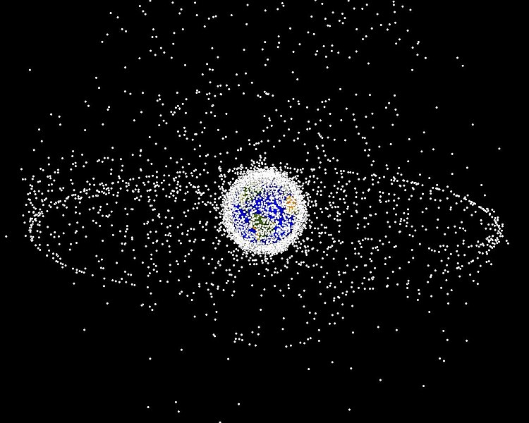
lots of crap up there tho

750px-Debris-GEO1280.jpg
 

Verite

My little pony.. my little pony
Veteran
It appears that some of those pics are showing everything classified as a 'satellite'. Which includes non functional man made space debris. Minus that and your left with about 560 operational satellites.

The United States Space Surveillance Network (SSN) has been tracking space objects since 1957 when the Soviets opened the space age with the launch of Sputnik I. Since then, the SSN has tracked more than 26,000 space objects orbiting Earth. The SSN currently tracks more than 8,000 man-made orbiting objects. The rest have re-entered Earth's turbulent atmosphere and disintegrated, or survived re-entry and impacted the Earth. The space objects now orbiting Earth range from satellites weighing several tons to pieces of spent rocket bodies weighing only 10 pounds. About seven percent of the space objects are operational satellites (i.e. ~560 satellites), the rest are space debris. USSTRATCOM is primarily interested in the active satellites, but also tracks space debris which upon reentry might otherwise be mistaken for incoming missiles. The SSN tracks space objects that are 10 centimeters in diameter (baseball size) or larger.

http://en.wikipedia.org/wiki/Satellite
 
its important to track space debris though... if your orbiting earth its good to know when a 10 lb. chunk of rock is coming towards you at 15,000 mph.
 

NiteTiger

Tiger, Tiger, burning bright...
Veteran
Jack D Ripper said:
its important to track space debris though... if your orbiting earth its good to know when a 10 lb. chunk of rock is coming towards you at 15,000 mph.

Good to know even if it's only half-pound chunk of rock coming at 15k mph :biglaugh:
 
Unless they were running these Satelite images Realtime I dont think their is much to worry about. The current photo of my house on Google Earth still has an image of a car I wrecked almost 9 or so months ago.
 
Top