St. Phatty
Active member
https://oe.oregonexplorer.info/craterlake//dem.html
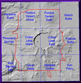
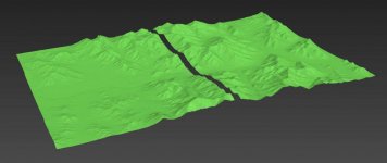
That's a picture of Crater Lake. I think they used topo maps with 10 meter resolution.
I'm trying to get more detailed Digital Elevation Model (DEM) files of the US.
I think if a person worked for the military or NSA they could subscribe to it - or they generate it.
So far the best I have found is 7.5 minute (1/8 of a degree), with 10 meter or 30 meter resolution.
The files work out to be about 10 kilometers by 14 kilometers, or maybe 6 miles by 8 miles.

They fit together like puzzle pieces on the computer.
I figure there are other people here who are into surveying, maps, etc.
I was trying to avoid a parcel of land but already surrendered and started drawing it.
That's a picture of Crater Lake. I think they used topo maps with 10 meter resolution.
I'm trying to get more detailed Digital Elevation Model (DEM) files of the US.
I think if a person worked for the military or NSA they could subscribe to it - or they generate it.
So far the best I have found is 7.5 minute (1/8 of a degree), with 10 meter or 30 meter resolution.
The files work out to be about 10 kilometers by 14 kilometers, or maybe 6 miles by 8 miles.
They fit together like puzzle pieces on the computer.
I figure there are other people here who are into surveying, maps, etc.
I was trying to avoid a parcel of land but already surrendered and started drawing it.