It is time we all start splurging our knowledge on growing, not only in general but growing in specific states and territories.
Everyone here has to have recognized that a large majority of outdoor growing information on IC is focused on Europe and the Americas. My intention here is for all aussie growers to contribute any knowledge that could help others down under. These catagories could include; fertilizers, strains, sow/harvest times etc..
Day light legnth tool(s) http://pictures.marijuana.com/galle...1257_p17846.swf (cited by Puresativa420 )
http://www.timeanddate.com/worldclock/sunrise.html (sunrise/set times for any location, cited by twenty47red-i)
Growing Season(s)
Australia
Plant: Late September, Early October
Flowering: February
Harvest: March/April
Winter Solstice: 21st June
Summer Solstice: 21 December
Why would you want to know the summer and winter solstice?
The winter solstice marks the shortest day in the year, which is normally 9 and a bit hours+. From this point forward day length increases till its apex, the summer solstice, at which point day length decreases. The astute grower will be well aware of this fact, because these key dates never change and provide a time-frame for growers. As when you grow indoors, an increasing lighting schedule results in vegetative growth as opposed to a decreasing schedule that results in flowering. In essence the indoor grower is mimicking the outdoor seasons by reducing/increasing light hours.
Use the time&date tool and check out day length in your area. Note the increase in day light hours after the winter solstice and decrease after the summer solstice. Our favorite plants growth stages are triggered by the amount of daylight/dark it receives, about 12 hours with increasing length encourages vegetative growth and vise versa.
There are alot of threads on IC about when to plant clones outdoors without causing them to flower, well since we all now know the daylight length for your given area, it would seem logical to condition clones to the light length that would be present outdoors when you plant. In this way you mimmic outdoor conditions, im not saying this is fool proof since genetics and other factors contribute but its worked most times than not for yours truly.
I believe some people on this forums have claimed to get multiple crops a year, i'm not saying it isn't workable but i would like you to post dates, times, strain etc etc so other may replicate it.
Strains
C99 - lots of vigor,Large Yields,medium feeder,Medium dense flowers
White Widow - lots of vigor, medium yields, high feeder, high dense flowers
Strawberry Web x Molakai Frost - slow, low yields,low feeder, airy flowers
Afghani x Columbian - lots of vigor, high yields, high feeder, medium dense flowers
Soil Texture
http://www.icmag.com/ic/showthread.php?t=49474&highlight=Soil+Texture (Backcountry)
WA:
Perth region: Sandy Loam/Loamy Sandy (needs added Peat moss, Coco coir, weak compost or mixtures)
Perth Soils
Western Australia and certainly Perth is very sandy. But there are sands and sands. If you are used to decent soils, you probably can't see much point in subdividing sands. Yet it does matter. Suppose you compare a soil with 2% water holding capacity with one with 6 %. They are both at the bottom of the scale but one has 3 times the capacity of the other.

1. Yellow: Soils of the youngest dunes. Usually very coarse sand with low water holding capacity. Pale yellow sub-soils, lime at some depth, tuart trees when far enough from the coastal winds
2. Orange: Soils of somewhat older dunes. Deep yellow sub-soil with fair water holding capacity often with lime. Tuart trees
3. Grey: Soils of the oldest dunes. Coarse sands, strongly leached with pale yellow sub-soils
4a. Green: Alluvial soils. A mixture, some with heavy texture and high water holding capacity.
4b. Maroon: Sandy surface soils overlying alluvial soils
5. Red: Soils of the Darling range and scarp, many with much pea-sized gravel
(Contributed by unknown)
The south-west region of WA is dominated by the swan coastal plain, a coastal plain created by the sediment build up from the elluvial movements from the yilgarn craton and the transgressional oceanic movements. This created a succession of dune systems that run parallel to the shoreline. There are three major systems all varying in age which is dependent upon their distance from the current shoreline. The youngest is the Quindalup dune system, which is the current shoreline, second is the spearwood dune system and thirdly the oldest is the bassadean dune system.
You growers may be thinking, now why the hell do i need to know about this? Well girls and boys it is this unique geology that has created the soils of the SCP, and knowing the properties of the soil complexes within the SCP could make or break your grow.
Quindalup Dunes
The youngest of the dunes, located on the coast trending North-South from Dongra to Dunsbrough(P.Sanderson, 1989). Consisting of mainly unconsolidated sand, quartz and shell fragments , that lay on top of Tamala limestone. The calcium carbonate found in abundance in shell fragments create a alkaline soil. The calcium carbonate in the soil profile dissolves in water and moves down the profile to be deposited at the base of the dunes as limestone(Rippey, E,2000). The Quindlup dunes are highly infertile and easily eroded without native plant cover. The close proximity of the Quindlup dunes to the ocean means only select plants can tolerate the variability of conditions.
Spearwood Dunes
The Spearwood dunes system is the most elevated, due to its age, 40, 000+ years, the Spearwood system has experienced greater leeching than the Quindalup dunes and thus has a reduced calcium carbonate content. The Spearwood dunes are lime-cemented dunes meaning they have a underlying basement rock of Tamala limestone.
Bassadean Dunes
The oldest of the dune systems, 800, 000+ years old and the most leached. The Bassadean dunes are infertile, have a acidic soil Ph and the soils have a poor nutrient content. The soils consist of a small organic horizon, sand consisting of little silt of clay. Dune system is low lying hills with poorly drained rifts between hills(Bolland, M., 2004) .
Soil Units
There are four major aeolian soils on the SCP each has unique soil properties and associations with particular dune systems.
The three main soils and associated characteristic are;
Karrakatta – Yellow sands * iron/Al oxide coating
Cottosloe – Red/Brown sands * Iron oxide coating
Quindalup – Sandy white
Bassadean – Orange/Brown sands

(APACE,2009) Fig 1
Each dune system has 1-3 associated soil units, with each soil unit forming a band running parallel to the coast. Quindalup is associated with the Quindalup soil unit, found closest to the shoreline. Further inland, the oldest Quindalup dunes, bordering the Quindalup/Spearwood dunes the Cottasloe soil unit occurs.
Spearwood dunes are associated with the Cottosloe and Karrakatta soil units. The Spearwood dunes border with the Quindalup dunes is where the Cottosloe soil unit occurs, further inland the Karrakatta soils are found, accounting for the majority of the dunes. The Red/Brown sands are only found near the Quindalup dunes and are originally deep in profile, unless exposed by wind erosion. The cottosloe sands are coated with iron oxides. The yellow sands, the yellow phase of the Karrakatta sands are to the west of the Spearwood dunes, the paler yellow/grey sands, the grey phase of the Karrakatta sands occur to the east.
The Bassadean dune system has three soil units, Jandakot sands, Gavin Sands and Joel sands. Jandakot sands occur on the crest and upper slopes of ridges and are well drained. Gavin soils occur further downslope, about 2M from the water table. Joel sands are a sandy loam soil type that occur in the lowest part of the dune system, where the water table is close to the surface.
Now what does this mean, well the soils are SANDY! with poor organic horizons, and thus have to have several organic amendments added to make it suitable. Soils also have poor water holding characteristics that have to be remedied! Also as the soils age, they are leached by rains, creating a acidic environment, PH can fluctuate greatly over the SCP, Check you H+ and -OH ions.
SA:
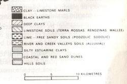
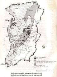
Adelaide

Victoria
Soil pH map of Victoria
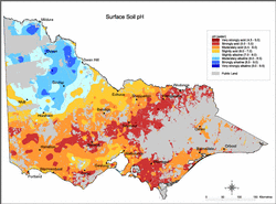
It is important to note that the map only considers surface soil pH. In many Victorian soils, pH will increase with depth.
Public land & parks etc. have been excluded.
---------------------------------------------------------------------
New South Wales
These maps should help any one planning on a guerrilla style grow this year in NSW.
New South Wales rainfall deciles - 12 months – 1 Aug 2006 – 31 July 2007
http://www.bom.gov.au/cgi-bin/climat...month&area=nsw
New South Wales rainfall deciles - 24 months – 1 Aug 2005 – 31 July 2007
http://www.bom.gov.au/cgi-bin/climat...month&area=nsw
Areas of NSW suffering drought conditions as at August 2007
http://www.agric.nsw.gov.au/reader/d...0708-large.gif
(contributed by smurf, 2007)
NT -
Having problems copy and pasting some of the images and text from other peoples posts, maybe someone could help! Much appreciated!
bt
Everyone here has to have recognized that a large majority of outdoor growing information on IC is focused on Europe and the Americas. My intention here is for all aussie growers to contribute any knowledge that could help others down under. These catagories could include; fertilizers, strains, sow/harvest times etc..
Day light legnth tool(s) http://pictures.marijuana.com/galle...1257_p17846.swf (cited by Puresativa420 )
http://www.timeanddate.com/worldclock/sunrise.html (sunrise/set times for any location, cited by twenty47red-i)
Growing Season(s)
Australia
Plant: Late September, Early October
Flowering: February
Harvest: March/April
Winter Solstice: 21st June
Summer Solstice: 21 December
Why would you want to know the summer and winter solstice?
The winter solstice marks the shortest day in the year, which is normally 9 and a bit hours+. From this point forward day length increases till its apex, the summer solstice, at which point day length decreases. The astute grower will be well aware of this fact, because these key dates never change and provide a time-frame for growers. As when you grow indoors, an increasing lighting schedule results in vegetative growth as opposed to a decreasing schedule that results in flowering. In essence the indoor grower is mimicking the outdoor seasons by reducing/increasing light hours.
Use the time&date tool and check out day length in your area. Note the increase in day light hours after the winter solstice and decrease after the summer solstice. Our favorite plants growth stages are triggered by the amount of daylight/dark it receives, about 12 hours with increasing length encourages vegetative growth and vise versa.
There are alot of threads on IC about when to plant clones outdoors without causing them to flower, well since we all now know the daylight length for your given area, it would seem logical to condition clones to the light length that would be present outdoors when you plant. In this way you mimmic outdoor conditions, im not saying this is fool proof since genetics and other factors contribute but its worked most times than not for yours truly.
I believe some people on this forums have claimed to get multiple crops a year, i'm not saying it isn't workable but i would like you to post dates, times, strain etc etc so other may replicate it.
Strains
C99 - lots of vigor,Large Yields,medium feeder,Medium dense flowers
White Widow - lots of vigor, medium yields, high feeder, high dense flowers
Strawberry Web x Molakai Frost - slow, low yields,low feeder, airy flowers
Afghani x Columbian - lots of vigor, high yields, high feeder, medium dense flowers
Soil Texture
http://www.icmag.com/ic/showthread.php?t=49474&highlight=Soil+Texture (Backcountry)
WA:
Perth region: Sandy Loam/Loamy Sandy (needs added Peat moss, Coco coir, weak compost or mixtures)
Perth Soils
Western Australia and certainly Perth is very sandy. But there are sands and sands. If you are used to decent soils, you probably can't see much point in subdividing sands. Yet it does matter. Suppose you compare a soil with 2% water holding capacity with one with 6 %. They are both at the bottom of the scale but one has 3 times the capacity of the other.

1. Yellow: Soils of the youngest dunes. Usually very coarse sand with low water holding capacity. Pale yellow sub-soils, lime at some depth, tuart trees when far enough from the coastal winds
2. Orange: Soils of somewhat older dunes. Deep yellow sub-soil with fair water holding capacity often with lime. Tuart trees
3. Grey: Soils of the oldest dunes. Coarse sands, strongly leached with pale yellow sub-soils
4a. Green: Alluvial soils. A mixture, some with heavy texture and high water holding capacity.
4b. Maroon: Sandy surface soils overlying alluvial soils
5. Red: Soils of the Darling range and scarp, many with much pea-sized gravel
(Contributed by unknown)
The south-west region of WA is dominated by the swan coastal plain, a coastal plain created by the sediment build up from the elluvial movements from the yilgarn craton and the transgressional oceanic movements. This created a succession of dune systems that run parallel to the shoreline. There are three major systems all varying in age which is dependent upon their distance from the current shoreline. The youngest is the Quindalup dune system, which is the current shoreline, second is the spearwood dune system and thirdly the oldest is the bassadean dune system.
You growers may be thinking, now why the hell do i need to know about this? Well girls and boys it is this unique geology that has created the soils of the SCP, and knowing the properties of the soil complexes within the SCP could make or break your grow.
Quindalup Dunes
The youngest of the dunes, located on the coast trending North-South from Dongra to Dunsbrough(P.Sanderson, 1989). Consisting of mainly unconsolidated sand, quartz and shell fragments , that lay on top of Tamala limestone. The calcium carbonate found in abundance in shell fragments create a alkaline soil. The calcium carbonate in the soil profile dissolves in water and moves down the profile to be deposited at the base of the dunes as limestone(Rippey, E,2000). The Quindlup dunes are highly infertile and easily eroded without native plant cover. The close proximity of the Quindlup dunes to the ocean means only select plants can tolerate the variability of conditions.
Spearwood Dunes
The Spearwood dunes system is the most elevated, due to its age, 40, 000+ years, the Spearwood system has experienced greater leeching than the Quindalup dunes and thus has a reduced calcium carbonate content. The Spearwood dunes are lime-cemented dunes meaning they have a underlying basement rock of Tamala limestone.
Bassadean Dunes
The oldest of the dune systems, 800, 000+ years old and the most leached. The Bassadean dunes are infertile, have a acidic soil Ph and the soils have a poor nutrient content. The soils consist of a small organic horizon, sand consisting of little silt of clay. Dune system is low lying hills with poorly drained rifts between hills(Bolland, M., 2004) .
Soil Units
There are four major aeolian soils on the SCP each has unique soil properties and associations with particular dune systems.
The three main soils and associated characteristic are;
Karrakatta – Yellow sands * iron/Al oxide coating
Cottosloe – Red/Brown sands * Iron oxide coating
Quindalup – Sandy white
Bassadean – Orange/Brown sands

(APACE,2009) Fig 1
Each dune system has 1-3 associated soil units, with each soil unit forming a band running parallel to the coast. Quindalup is associated with the Quindalup soil unit, found closest to the shoreline. Further inland, the oldest Quindalup dunes, bordering the Quindalup/Spearwood dunes the Cottasloe soil unit occurs.
Spearwood dunes are associated with the Cottosloe and Karrakatta soil units. The Spearwood dunes border with the Quindalup dunes is where the Cottosloe soil unit occurs, further inland the Karrakatta soils are found, accounting for the majority of the dunes. The Red/Brown sands are only found near the Quindalup dunes and are originally deep in profile, unless exposed by wind erosion. The cottosloe sands are coated with iron oxides. The yellow sands, the yellow phase of the Karrakatta sands are to the west of the Spearwood dunes, the paler yellow/grey sands, the grey phase of the Karrakatta sands occur to the east.
The Bassadean dune system has three soil units, Jandakot sands, Gavin Sands and Joel sands. Jandakot sands occur on the crest and upper slopes of ridges and are well drained. Gavin soils occur further downslope, about 2M from the water table. Joel sands are a sandy loam soil type that occur in the lowest part of the dune system, where the water table is close to the surface.
Now what does this mean, well the soils are SANDY! with poor organic horizons, and thus have to have several organic amendments added to make it suitable. Soils also have poor water holding characteristics that have to be remedied! Also as the soils age, they are leached by rains, creating a acidic environment, PH can fluctuate greatly over the SCP, Check you H+ and -OH ions.
SA:
Adelaide


Victoria
Soil pH map of Victoria

It is important to note that the map only considers surface soil pH. In many Victorian soils, pH will increase with depth.
Public land & parks etc. have been excluded.
---------------------------------------------------------------------
New South Wales
These maps should help any one planning on a guerrilla style grow this year in NSW.
New South Wales rainfall deciles - 12 months – 1 Aug 2006 – 31 July 2007
http://www.bom.gov.au/cgi-bin/climat...month&area=nsw
New South Wales rainfall deciles - 24 months – 1 Aug 2005 – 31 July 2007
http://www.bom.gov.au/cgi-bin/climat...month&area=nsw
Areas of NSW suffering drought conditions as at August 2007
http://www.agric.nsw.gov.au/reader/d...0708-large.gif
(contributed by smurf, 2007)
NT -
Having problems copy and pasting some of the images and text from other peoples posts, maybe someone could help! Much appreciated!
bt
Last edited:




 Good luck fellas.


